IMAGES TAKEN NEAR TO
Luckwell Road, BRISTOL, BS3 3HA
Introduction
This page details the photographs taken nearby to Luckwell Road, BS3 3HA by members of the Geograph project.
The Geograph project started in 2005 with the aim of publishing, organising and preserving representative images for every square kilometre of Great Britain, Ireland and the Isle of Man.

There are currently over 7.5m images from over14,400 individuals and you can help contribute to the project by visiting https://www.geograph.org.uk
Image Map
Images are licensed for reuse under creativecommons.org/licenses/by-sa/2.0
Notes
- Clicking on the map will re-center to the selected point.
- The higher the marker number, the further away the image location is from the centre of the postcode.
Image Listing (100 Images Found)
Images are licensed for reuse under creativecommons.org/licenses/by-sa/2.0
Image
Details
Distance
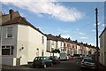
1
Longstanding Local
Palmyra Road, Bedminster
Image: © Anthony O'Neil
Taken: 9 Feb 2021
0.03 miles
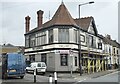
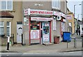
2
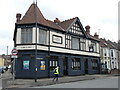
The Luckwell
An old pub that was part of the first expansion in this part of Bristol back in the late 1800s. It has a long history but has only recently undergone an expensive refurbishment. Former Bristol City F.C. player Tommy Doherty officially marked the reopening in late 2021.
Image: © Neil Owen
Taken: 17 Feb 2022
0.03 miles
3
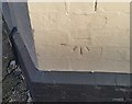
Ordnance Survey Cut Mark
This OS cut mark can be found on the Luckwell Hotel. It marks a point 36.09m above mean sea level.
Image: © Adrian Dust
Taken: 18 Jan 2020
0.03 miles
4
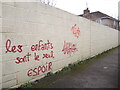
'Les enfants sont le seul espoir'
High brow graffiti on a short lane in Ashton. It translates as 'the children are the only hope'.
Image: © Neil Owen
Taken: 17 Feb 2022
0.03 miles
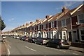
5
West View Road, Bristol
Looking up the terraced street from the T junction with Aubrey Road.
Image: © Derek Harper
Taken: 15 Mar 2014
0.04 miles
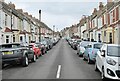
7
Luckwell Road, Bristol
From its junction with Duckmoor Road.
Image: © Derek Harper
Taken: 15 Mar 2014
0.05 miles
9
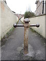
A bollard off Colliter Crescent
A short alleyway links the roads but is guarded by an old bollard.
Image: © Neil Owen
Taken: 17 Feb 2022
0.06 miles
10
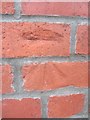
Ordnance Survey Cut Mark
This OS cut mark can be found on the wall on Palmyra Rd, 1.2m from the junction with Elmdale Rd. It marks a point 14.198m above mean sea level.
Image: © Adrian Dust
Taken: 8 Aug 2013
0.08 miles