IMAGES TAKEN NEAR TO
Clyde Terrace, BRISTOL, BS3 3BL
Introduction
This page details the photographs taken nearby to Clyde Terrace, BS3 3BL by members of the Geograph project.
The Geograph project started in 2005 with the aim of publishing, organising and preserving representative images for every square kilometre of Great Britain, Ireland and the Isle of Man.

There are currently over 7.5m images from over14,400 individuals and you can help contribute to the project by visiting https://www.geograph.org.uk
Image Map
Images are licensed for reuse under creativecommons.org/licenses/by-sa/2.0
Notes
- Clicking on the map will re-center to the selected point.
- The higher the marker number, the further away the image location is from the centre of the postcode.
Image Listing (470 Images Found)
Images are licensed for reuse under creativecommons.org/licenses/by-sa/2.0
Image
Details
Distance
1
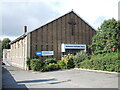
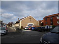
Bedminster Methodist church
Saving souls and jabbing arms. The church is a modern one dating from the mid twentieth century. Prior to that there was an older chapel and Sunday school here, dating from the late nineteenth. Yet earlier and to the right of shot was an Ebenezer (Wesleyan Methodist) chapel that stood in front of the school; both are lost now.
Image: © Neil Owen
Taken: 10 Sep 2021
0.02 miles
2
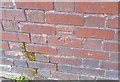
Ordnance Survey Cut Mark
This OS cut mark can be found on No1 Clyde Terrace. It marks a point 23.003m above mean sea level.
Image: © Adrian Dust
Taken: 12 Mar 2020
0.02 miles
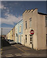
3
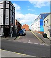
Westbourne Grove, Bedminster, Bristol
From the A38 West Street along Westbourne Grove towards British Road.
The Black Cat pub https://www.geograph.org.uk/photo/5895797 is on the left.
Image: © Jaggery
Taken: 5 Sep 2018
0.03 miles
4
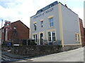
A tiara slipped
This corner pub in Bedminster was built in about 1863 as the terraces were developed locally. Now the last of that era, the pub struggled of late and sadly was closed. It has been bought up for conversion into residential use. See Image] for the old pub sign. The original Princess (later Queen) was Alexandra, the wife of the future Edward VII.
Image: © Neil Owen
Taken: 10 Sep 2021
0.03 miles
5
Bedminster Methodist Church, British Road
A modern church replacing a neo-classical church which stood on this site and was demolished in 1980.
Image: © Eirian Evans
Taken: 22 Feb 2018
0.03 miles
6
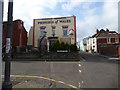
Princess of Wales
Pub, now closed, at the junction of Westbourne Close and British Road. Originally named after Princess Alexandra, the wife of Edward the seventh, the sign was changed for one for Princess Diana and inside the pub were many photographs of her hung on the walls amongst other royal related memorabilia.
Image: © Eirian Evans
Taken: 22 Feb 2018
0.03 miles
7
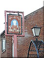
Diana fades
The Princess of Wales pub in Bedminster was named after Alexandra, (later Queen Alexandra), the wife of the future Edward VII. Given the image of the late Diana and the legacy that remains today, the present sign seems poignant. The pub closed a couple of years ago and was converted for residential use. See Image
Image: © Neil Owen
Taken: 10 Sep 2021
0.03 miles
8
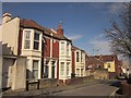
Houses on British Road, Bedminster
From the junction with Hebron Road and showing the junction with Braunton Road.
Image: © Derek Harper
Taken: 15 Mar 2014
0.03 miles
9
Hebron Road, Bedminster
A terrace of 29 properties on the north side of British Road. Hebron Road also runs south of British Road, but not directly opposite; you have to turn left and right.
Image: © Derek Harper
Taken: 15 Mar 2014
0.04 miles
10
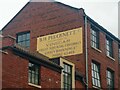
Old sign on the former B.H. Plucknett Vinegar Factory, Braunton Road
The sign reads 'B.H. Plucknett. C
Manufacturers of
Vinegar
Fruit squash & cordials
Gravy browning etc
Phone 63468'
Image: © s
Taken: 25 Feb 2023
0.04 miles