IMAGES TAKEN NEAR TO
Hebron Road, BRISTOL, BS3 3AB
Introduction
This page details the photographs taken nearby to Hebron Road, BS3 3AB by members of the Geograph project.
The Geograph project started in 2005 with the aim of publishing, organising and preserving representative images for every square kilometre of Great Britain, Ireland and the Isle of Man.

There are currently over 7.5m images from over14,400 individuals and you can help contribute to the project by visiting https://www.geograph.org.uk
Image Map
Images are licensed for reuse under creativecommons.org/licenses/by-sa/2.0
Notes
- Clicking on the map will re-center to the selected point.
- The higher the marker number, the further away the image location is from the centre of the postcode.
Image Listing (418 Images Found)
Images are licensed for reuse under creativecommons.org/licenses/by-sa/2.0
Image
Details
Distance
1
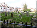
Graveyard, Hebron Chapel
This overgrown graveyard contains the grave of Princess Caribou - a poor Devonian woman who pretended to be Javanese princess and was feted by the wealthy & famous in the early 1800s. She died a pauper in 1864. https://en.wikipedia.org/wiki/Princess_Caraboo
Image: © Eirian Evans
Taken: 22 Feb 2018
0.02 miles
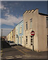
2
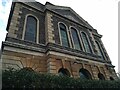
Hebron Court
Hebron Court used to be Hebron Chapel. It was built in 1853 on agricultural land, and had been designed by Henry Crisp. By 1883 it had become a United Free Methodist Chapel, with seats for 640 people. It has a Sunday school adjoined to the rear.
Image: © s
Taken: 13 Aug 2021
0.02 miles
3
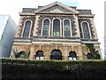
Hebron Court
Hebron Methodist Church, which opened in 1854, was the result of a devastating schism that split the Methodist Church in 1849.There were places in the new church for 470 people, and a further 110 in the gallery opposite the pulpit. Side galleries were added in 1867 and a further choir gallery erected behind the preacher’s rostrum in January 1872 increased the accommodation to 862 persons. The church closed in the 1960's due to falling numbers of congregants and the church was sold to the Spiritualists. In 2002 they moved out and the property was bought by developers who converted it into flats. http://www.well-and.co.uk/Welland-p/pi138.htm
Image: © Eirian Evans
Taken: 22 Feb 2018
0.02 miles
4
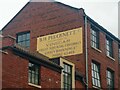
Old sign on the former B.H. Plucknett Vinegar Factory, Braunton Road
The sign reads 'B.H. Plucknett. C
Manufacturers of
Vinegar
Fruit squash & cordials
Gravy browning etc
Phone 63468'
Image: © s
Taken: 25 Feb 2023
0.03 miles
5
Braunton Road looking Southeast
Looking towards the B.H. Plucknett Vinegar Factory.
Image: © s
Taken: 25 Feb 2023
0.03 miles
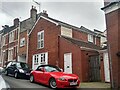
6
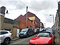
Hebron Road, Bedminster
A terrace of 29 properties on the north side of British Road. Hebron Road also runs south of British Road, but not directly opposite; you have to turn left and right.
Image: © Derek Harper
Taken: 15 Mar 2014
0.03 miles
7
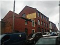
Former B.H. Plucknett Vinegar Factory, Braunton Road
Image: © s
Taken: 25 Feb 2023
0.04 miles
8
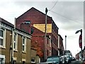
Former B.H. Plucknett. C Vinegar Manufacturers, Braunton Road
Image: © s
Taken: 25 Feb 2023
0.04 miles
9
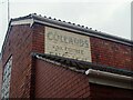
Old sign on the former Collards Butchers
Collards Butchers opened in the 1850s. It later expanded to shops in Bedminster Parade, Redcliffe, Clifton, and Old Market. This shop closed in the 1980s. Alfred Daw Collard was the owner of the shop during the 1900s.
Image: © s
Taken: 25 Feb 2023
0.04 miles
10
Former Collards Butchers, Braunton Road
Collards Butchers opened in the 1850s. It later expanded to shops in Bedminster Parade, Redcliffe, Clifton, and Old Market. This shop closed in the 1980s. Alfred Daw Collard was the owner of the shop during the 1900s.
Image: © s
Taken: 25 Feb 2023
0.04 miles