IMAGES TAKEN NEAR TO
South Liberty Lane, BRISTOL, BS3 2ST
Introduction
This page details the photographs taken nearby to South Liberty Lane, BS3 2ST by members of the Geograph project.
The Geograph project started in 2005 with the aim of publishing, organising and preserving representative images for every square kilometre of Great Britain, Ireland and the Isle of Man.

There are currently over 7.5m images from over14,400 individuals and you can help contribute to the project by visiting https://www.geograph.org.uk
Image Map
Images are licensed for reuse under creativecommons.org/licenses/by-sa/2.0
Notes
- Clicking on the map will re-center to the selected point.
- The higher the marker number, the further away the image location is from the centre of the postcode.
Image Listing (54 Images Found)
Images are licensed for reuse under creativecommons.org/licenses/by-sa/2.0
Image
Details
Distance
1
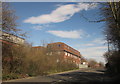
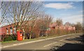
Liberty House
A purpose-built office building on South Liberty Lane. On the left are premises on the Liberty Industrial Park.
Image: © Derek Harper
Taken: 15 Mar 2014
0.01 miles
2
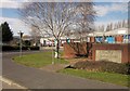
Liberty Industrial Park
Another view of the entrance to the estate shown in Image
Image: © Derek Harper
Taken: 15 Mar 2014
0.03 miles
3
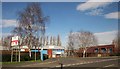
Liberty Industrial Park
The entrance to the estate from South Liberty Lane.
Image: © Derek Harper
Taken: 15 Mar 2014
0.03 miles
4
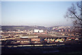
View towards Ashton Park from Bedminster Down, Bristol
Image: © Colin Park
Taken: 15 Dec 1974
0.03 miles
5
Liberty Industrial Park
This large unit at the east end of the estate is occupied by a firm of electrical cable distributors. On the left, on South Liberty Lane, is what I take to be postbox BS3 4008, for franked mail only, though no number is visible on the plate. There is no royal cipher.
Image: © Derek Harper
Taken: 15 Mar 2014
0.06 miles


8
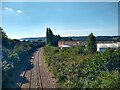
Portishead Railway looking West
The Portishead Railway opened in 1867, and was closed for passengers in 1964. The line closed to freight traffic in 1981. In 2002 the railway was rebuilt to the Royal Portbury Dock. The photo was taken from South Liberty Lane.
Image: © s
Taken: 6 Aug 2022
0.09 miles
9
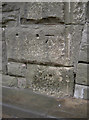
Benchmark on the railway bridge
A cutmark (as listed in the Benchmark Database: http://www.bench-marks.org.uk/bm40659 ) on the supporting flank of a bridge in South Liberty Lane, Ashton. See Image] for a wider view.
Image: © Neil Owen
Taken: 29 Dec 2011
0.09 miles
10
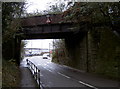
Railway bridge along South Liberty Lane
This little bridge carries a freight down towards Ashton Vale and on along the Avon Gorge. On the right-hand side is a benchmark - see Image
Image: © Neil Owen
Taken: 29 Dec 2011
0.09 miles