IMAGES TAKEN NEAR TO
South Liberty Lane, BRISTOL, BS3 2SS
Introduction
This page details the photographs taken nearby to South Liberty Lane, BS3 2SS by members of the Geograph project.
The Geograph project started in 2005 with the aim of publishing, organising and preserving representative images for every square kilometre of Great Britain, Ireland and the Isle of Man.

There are currently over 7.5m images from over14,400 individuals and you can help contribute to the project by visiting https://www.geograph.org.uk
Image Map
Images are licensed for reuse under creativecommons.org/licenses/by-sa/2.0
Notes
- Clicking on the map will re-center to the selected point.
- The higher the marker number, the further away the image location is from the centre of the postcode.
Image Listing (61 Images Found)
Images are licensed for reuse under creativecommons.org/licenses/by-sa/2.0
Image
Details
Distance
1
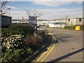
Phoenix Business Park, Bristol
Off South Liberty Lane. Prominent are the premises of Bailey Caravans, "the longest established UK manufacturer".
At larger sizes, you might spot the Clifton Suspension Bridge in the distance.
Image: © Derek Harper
Taken: 15 Mar 2014
0.07 miles
2
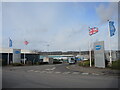
The entrance to Bailey's Caravans
The manufacturer has a large and busy site where the caravans are crafted. Originally this site was a clay pit and brickworks, before being filled in and becoming a builder's yard.
Image: © Neil Owen
Taken: 17 Feb 2022
0.09 miles
3
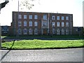
HMS Flying Fox
Naval Reserve Base. Winterstoke Road. Bristol.
Image: © Mr Andrew Clark
Taken: 1 Nov 2005
0.09 miles
4
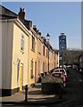
Nelson Street, Bedminster
A view up the "Victory Home Zone" shown in Image
Image: © Derek Harper
Taken: 15 Mar 2014
0.10 miles
5
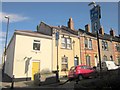
Nelson Street, Bedminster
The blue notices proclaim this as a "Victory Home Zone". "The Victory Home Zone in Bedminster was completed in September 2002 with features such as speed cushions, new lighting, trees, planters and a new play area ... Home Zone is a street or group of streets that aims to create an environment that is more than
just a place for cars to park. It should invite its residents to view it as a space for people with particular emphasis on the safer movement of pedestrians and cyclists. Vehicular traffic should travel at little more than walking pace" www.eltis.org/PDF/generate_pdf.php?study_id=664&lan=en .
Image: © Derek Harper
Taken: 15 Mar 2014
0.10 miles
7
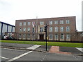
HMS Flying Fox, Winterstoke Road
This is the Bristol base of the Royal Navy Reserve. It trains over 100 reservists every week.
Image: © Eirian Evans
Taken: 9 Jun 2022
0.11 miles
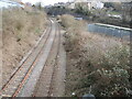
8
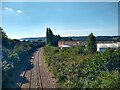
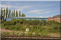
Portishead Railway looking West
The Portishead Railway opened in 1867, and was closed for passengers in 1964. The line closed to freight traffic in 1981. In 2002 the railway was rebuilt to the Royal Portbury Dock. The photo was taken from South Liberty Lane.
Image: © s
Taken: 6 Aug 2022
0.12 miles
9
Portishead Railway looking East
The Portishead Railway opened in 1867, and was closed for passengers in 1964. The line closed to freight traffic in 1981. In 2002 the railway was rebuilt to the Royal Portbury Dock. The photo was taken from South Liberty Lane.
Image: © s
Taken: 6 Aug 2022
0.12 miles
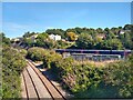
10
The scene from South Liberty Lane bridge
Branching off from the main south-west routes are the tracks to Ashton, the Portway and which eventually fizzle out before reaching Portishead.
Image: © Neil Owen
Taken: 17 Feb 2022
0.13 miles