IMAGES TAKEN NEAR TO
Tregarth Road, BRISTOL, BS3 2QS
Introduction
This page details the photographs taken nearby to Tregarth Road, BS3 2QS by members of the Geograph project.
The Geograph project started in 2005 with the aim of publishing, organising and preserving representative images for every square kilometre of Great Britain, Ireland and the Isle of Man.

There are currently over 7.5m images from over14,400 individuals and you can help contribute to the project by visiting https://www.geograph.org.uk
Image Map
Images are licensed for reuse under creativecommons.org/licenses/by-sa/2.0
Notes
- Clicking on the map will re-center to the selected point.
- The higher the marker number, the further away the image location is from the centre of the postcode.
Image Listing (25 Images Found)
Images are licensed for reuse under creativecommons.org/licenses/by-sa/2.0
Image
Details
Distance
1
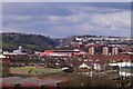
From the A38 across Ashton Gate to the Clifton Bridge
View looking north.
Image: © MJ Reilly
Taken: 23 Mar 2008
0.05 miles
2
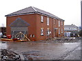
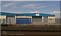
New for old
A modern housing development is taking shape along South Liberty Lane. 'Bluebell Drive' will soon be home to dozens of families, having replaced a number of prefabs that were occupying this part of south Bristol. Indeed, one or two of the homely little houses are still close by, the occupants having bought and improved them considerably.
Image: © Neil Owen
Taken: 19 Dec 2011
0.06 miles
3
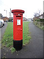
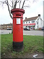
Risdale Road letterbox
A Georgian variety, located in a part of south Bristol that was open fields before WWII, and soon became an estate made largely from 'pre-fabs'.
Image: © Neil Owen
Taken: 17 Feb 2022
0.07 miles

6
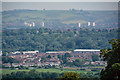
Long Ashton : Countryside Scenery
Looking down into Long Ashton from Ashton Court Estate.
Image: © Lewis Clarke
Taken: 26 Jun 2020
0.11 miles
8
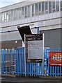
Trading estate information board
The eastern end of South Liberty Lane trading estate has a board to identify the various companies. See Image] and Image] for more views. The road is named after the South Liberty coal mine, which was further west and produced coal from the mid eighteenth century right up until 1925.
Image: © Neil Owen
Taken: 10 Sep 2011
0.13 miles
9
Victorian letterbox in an post-war estate
The Ashton Drive area did not appear until after WWII, so this Handyside letterbox is clearly in a new place.
Image: © Neil Owen
Taken: 17 Feb 2022
0.13 miles
10

Footbridge at Liberty Lane
View from the footbridge at Liberty Lane near Bristol.
Image: © Wayland Smith
Taken: 24 Jul 2007
0.14 miles