IMAGES TAKEN NEAR TO
Ashton Rise, BRISTOL, BS3 2DT
Introduction
This page details the photographs taken nearby to Ashton Rise, BS3 2DT by members of the Geograph project.
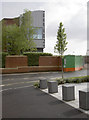
The Geograph project started in 2005 with the aim of publishing, organising and preserving representative images for every square kilometre of Great Britain, Ireland and the Isle of Man.

There are currently over 7.5m images from over14,400 individuals and you can help contribute to the project by visiting https://www.geograph.org.uk
Image Map
Images are licensed for reuse under creativecommons.org/licenses/by-sa/2.0
Notes
- Clicking on the map will re-center to the selected point.
- The higher the marker number, the further away the image location is from the centre of the postcode.
Image Listing (85 Images Found)
Images are licensed for reuse under creativecommons.org/licenses/by-sa/2.0
Image
Details
Distance
1
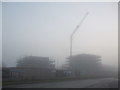
New housing looming in the gloom
Ashton Vale is about to be endowed with new housing for about 130 residences. As part of the city's commitment to providing more (affordable!) homes a part of the land by Alderman Moore's allotments is given over to them. Fog rolled in all day and makes for an unusual image.
Image: © Neil Owen
Taken: 30 Dec 2019
0.06 miles
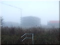
3
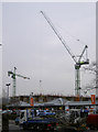
One of each
Two types of crane are at work on Imperial Tobacco's new building - sliding on the left and luffing on the right. Compare to the 2014 shot of the completed construction - Image
Image: © Neil Owen
Taken: 9 Feb 2012
0.08 miles
4
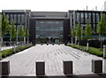
Shiny new offices
Imperial Tobacco used to have a large presence in the Ashton area for many years. However, the old bonds were blown up in the 1990s and the older blocks cleared recently to make way for these new ones. Compare with Image] for the work of building them.
Image: © Neil Owen
Taken: 28 Apr 2014
0.08 miles
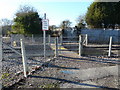
5
A new conduit for Colliter's Brook
The brook is now carried under the railway line by a new set of pipes.
Image: © Neil Owen
Taken: 30 Dec 2019
0.08 miles
6
Rising above the fog in Ashton Vale
Ashton Rise: the new housing development in Ashton Vale as seen through fog from Colliter's Brook.
Image: © Neil Owen
Taken: 30 Dec 2019
0.08 miles
7
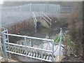
Pedestrian Level Crossing in Ashton Vale
Image: © Anthony O'Neil
Taken: 20 Jan 2011
0.09 miles
9
Half and half
Some of the old Imperial Tobacco offices in Winterstoke Road; part of it was demolished and a new structure built onto the rest.
Image: © Neil Owen
Taken: 28 Apr 2014
0.11 miles
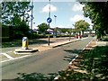
10
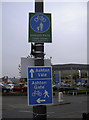
Share and share alike
A number of signs to guide the traveller, be they on foot or on wheels. However, the actual pavement doesn't seem to have any dividing line as most shared paths do.
Image: © Neil Owen
Taken: 9 Feb 2012
0.11 miles