IMAGES TAKEN NEAR TO
Harvest Close, BRISTOL, BS32 9DQ
Introduction
This page details the photographs taken nearby to Harvest Close, BS32 9DQ by members of the Geograph project.
The Geograph project started in 2005 with the aim of publishing, organising and preserving representative images for every square kilometre of Great Britain, Ireland and the Isle of Man.

There are currently over 7.5m images from over14,400 individuals and you can help contribute to the project by visiting https://www.geograph.org.uk
Image Map
Images are licensed for reuse under creativecommons.org/licenses/by-sa/2.0
Notes
- Clicking on the map will re-center to the selected point.
- The higher the marker number, the further away the image location is from the centre of the postcode.
Image Listing (6 Images Found)
Images are licensed for reuse under creativecommons.org/licenses/by-sa/2.0
Image
Details
Distance
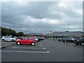
1
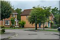
Bradley Stoke : The Brightwell
The Brightwell at the end of Wheatfield Drive.
Image: © Lewis Clarke
Taken: 11 Jul 2023
0.15 miles
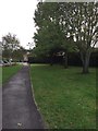
2
Bradley Stoke : Wheatfield Drive
Looking along Wheatfield Drive.
Image: © Lewis Clarke
Taken: 11 Jul 2023
0.16 miles
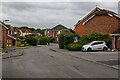
3
Bradley Stoke : Wheatfield Drive
Looking along Wheatfield Drive.
Image: © Lewis Clarke
Taken: 11 Jul 2023
0.16 miles
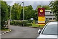
4
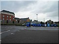
Recycling area Tesco extra Bradley Stoke
Image: © Steve Fareham
Taken: 6 Jul 2011
0.22 miles