IMAGES TAKEN NEAR TO
Carter Walk, BRISTOL, BS32 8EQ
Introduction
This page details the photographs taken nearby to Carter Walk, BS32 8EQ by members of the Geograph project.
The Geograph project started in 2005 with the aim of publishing, organising and preserving representative images for every square kilometre of Great Britain, Ireland and the Isle of Man.

There are currently over 7.5m images from over14,400 individuals and you can help contribute to the project by visiting https://www.geograph.org.uk
Image Map
Images are licensed for reuse under creativecommons.org/licenses/by-sa/2.0
Notes
- Clicking on the map will re-center to the selected point.
- The higher the marker number, the further away the image location is from the centre of the postcode.
Image Listing (11 Images Found)
Images are licensed for reuse under creativecommons.org/licenses/by-sa/2.0
Image
Details
Distance
4
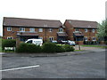
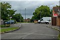
Bradley Stoke : The Willows
The Willows off Savages Wood Road.
Image: © Lewis Clarke
Taken: 11 Jul 2023
0.11 miles
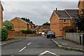
5
Bradley Stoke : The Beeches
Looking along a small road.
Image: © Lewis Clarke
Taken: 11 Jul 2023
0.13 miles

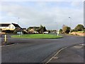
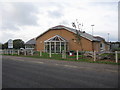
7
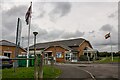
Bradley Stoke : The Jubilee Centre
A venue for use on Savages Wood Road.
Image: © Lewis Clarke
Taken: 11 Jul 2023
0.15 miles
8
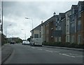
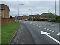
Savages Wood Road
Savages Wood Road passing the new housing which fronts onto Hornbeam Close, the next turning to the right.
Image: © Ruth Riddle
Taken: 22 Jun 2012
0.15 miles
9
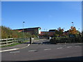
Meadowbrook Primary School
Meadowbrook Primary school, built as part of the Bradley Stoke development, north Bristol.
Image: © Phil Williams
Taken: 16 Nov 2005
0.16 miles
10
Bradley Stoke Town Council offices
looking north across Savages Wood Road to the offices of the Bradley Stoke Town Council.
Image: © Phil Williams
Taken: 24 Nov 2005
0.17 miles