IMAGES TAKEN NEAR TO
The Worthys, BRISTOL, BS32 8DQ
Introduction
This page details the photographs taken nearby to The Worthys, BS32 8DQ by members of the Geograph project.
The Geograph project started in 2005 with the aim of publishing, organising and preserving representative images for every square kilometre of Great Britain, Ireland and the Isle of Man.

There are currently over 7.5m images from over14,400 individuals and you can help contribute to the project by visiting https://www.geograph.org.uk
Image Map
Images are licensed for reuse under creativecommons.org/licenses/by-sa/2.0
Notes
- Clicking on the map will re-center to the selected point.
- The higher the marker number, the further away the image location is from the centre of the postcode.
Image Listing (12 Images Found)
Images are licensed for reuse under creativecommons.org/licenses/by-sa/2.0
Image
Details
Distance
1
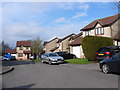
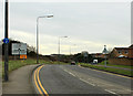
The Worthys
The Worthys is a road consisting mainly of numerous cul de sacs with small detached and semi detached houses with equally small gardens.
Image: © Nigel Mykura
Taken: 17 Mar 2013
0.02 miles
2
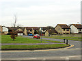
2012 : The Worthys, seen from Bradley Stoke Way
A residential road of good appearance.
Image: © Maurice Pullin
Taken: 16 Feb 2012
0.03 miles
3
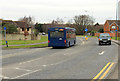
2012 : Local bus on Bradley Stoke Way
Heading north from Great Stoke to Bradley Stoke.
Image: © Maurice Pullin
Taken: 16 Feb 2012
0.06 miles
4
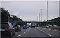
2012 : Approaching the Great Stoke roundabout
Heading south on Bradley Stoke Way.
Soon to join the B4057 link road between Winterbourne and Patchway
Image: © Maurice Pullin
Taken: 16 Feb 2012
0.08 miles
5

Edgeland Images, Desire path
A desire path at Bradley Stoke, running between Ellan Hay Road and Bradley Stoke way. Captured on Kindle.
Image: © Navsbooks
Taken: 2 Oct 2018
0.10 miles
6
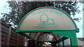
Great Meadow Bus stop
A bus shelter showing the Bradley Stoke logo.
Image: © Navsbooks
Taken: 7 Sep 2017
0.13 miles
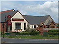
7
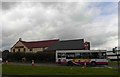
The Winter Stream Farm public house and a bus
Image: © Steve Fareham
Taken: 20 Aug 2015
0.23 miles
8
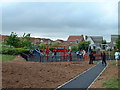
New Playground
At the W. edge of square a new playground at Bakers Ground, Stoke Gifford
Image: © John Phillips
Taken: 26 May 2005
0.23 miles
9
Winter Stream Farm
Clearly this is a new pub, not an actual farm; nor does the history of this site include a specific farm. Through most of the past it was open countryside until the twentieth century when this place was a clay pit and brickworks.
Image: © Neil Owen
Taken: 25 May 2019
0.24 miles