IMAGES TAKEN NEAR TO
Pursey Drive, BRISTOL, BS32 8DN
Introduction
This page details the photographs taken nearby to Pursey Drive, BS32 8DN by members of the Geograph project.
The Geograph project started in 2005 with the aim of publishing, organising and preserving representative images for every square kilometre of Great Britain, Ireland and the Isle of Man.

There are currently over 7.5m images from over14,400 individuals and you can help contribute to the project by visiting https://www.geograph.org.uk
Image Map
Images are licensed for reuse under creativecommons.org/licenses/by-sa/2.0
Notes
- Clicking on the map will re-center to the selected point.
- The higher the marker number, the further away the image location is from the centre of the postcode.
Image Listing (15 Images Found)
Images are licensed for reuse under creativecommons.org/licenses/by-sa/2.0
Image
Details
Distance
1
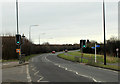
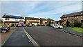
2012 : B4057 Crossing on the road to Winterbourne
Installed to protect motorists crossing this hazardous cycleway and footpath between Watch Elm Close and Mead Road.
Image: © Maurice Pullin
Taken: 16 Feb 2012
0.05 miles
2
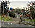
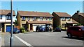
2012 : Mead Road and access path, Great Stoke
Or it might be Stoke Gifford.
A cycleway and footpath crosses the B4057 Winterbourne Road at the traffic lights.
Image: © Maurice Pullin
Taken: 16 Feb 2012
0.09 miles
3

Bradley Stoke Council Door
Logo of Bradley Stoke Council office door. Caught on Kindle
Image: © Navsbooks
Taken: 26 Sep 2017
0.10 miles
4

Bailey Court Pub, Bradley Stoke
One of the few Farm Houses to survive the Bradley Stoke housing development.
Image: © Steve Coffin
Taken: 19 Dec 2010
0.13 miles
5
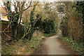
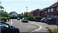
2012 : Lane to Watch Elm Close, Stoke Gifford
A short lane takes the pedestrian/cyclist from the B4057 Winterbourne Road to Watch Elm Close.
Image: © Maurice Pullin
Taken: 16 Feb 2012
0.16 miles
6
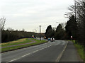
2012 : B4057 Winterbourne Road
Looking west toward Patchway and Filton.
The B4057 is a link road between Winterbourne and the A38 south of Patchway.
Image: © Maurice Pullin
Taken: 16 Feb 2012
0.18 miles
7
Tyrrel Way
The end of the cul-de-sac on Boxing Day 2021.
Image: © Jonathan Billinger
Taken: 26 Dec 2021
0.19 miles
8
Tyrrel Way, Stoke Gifford, 1
Part of the vast estate of late 20th century housing to the north of Bristol.
Image: © Jonathan Billinger
Taken: 17 Jun 2017
0.19 miles
9
Tyrrel Way, Stoke Gifford, 2
Part of the vast estate of late 20th century housing to the north of Bristol.
Image: © Jonathan Billinger
Taken: 17 Jun 2017
0.20 miles
10
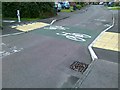
Cycle way crosses Arden Close, Stoke Gifford
Image: © Alex McGregor
Taken: 21 Jun 2011
0.21 miles