IMAGES TAKEN NEAR TO
Hayeley Drive, BRISTOL, BS32 8AE
Introduction
This page details the photographs taken nearby to Hayeley Drive, BS32 8AE by members of the Geograph project.
The Geograph project started in 2005 with the aim of publishing, organising and preserving representative images for every square kilometre of Great Britain, Ireland and the Isle of Man.

There are currently over 7.5m images from over14,400 individuals and you can help contribute to the project by visiting https://www.geograph.org.uk
Image Map
Images are licensed for reuse under creativecommons.org/licenses/by-sa/2.0
Notes
- Clicking on the map will re-center to the selected point.
- The higher the marker number, the further away the image location is from the centre of the postcode.
Image Listing (22 Images Found)
Images are licensed for reuse under creativecommons.org/licenses/by-sa/2.0
Image
Details
Distance
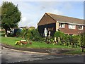
4
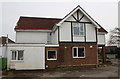
'Ringbourne', Winterbourne Road
There is an OS benchmark Image on the right hand corner of the house, left of a white downpipe
Image: © Roger Templeman
Taken: 12 Mar 2016
0.12 miles
5
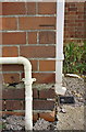
Benchmark on 'Ringbourne', Winterbourne Road
Ordnance Survey cut mark benchmark described on the Bench Mark Database at http://www.bench-marks.org.uk/bm74124
Image: © Roger Templeman
Taken: 12 Mar 2016
0.12 miles
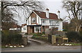
8
Hatchet Road heading south
Towards Stoke Gifford.
Image: © JThomas
Taken: 11 May 2013
0.14 miles