IMAGES TAKEN NEAR TO
Aztec West, BRISTOL, BS32 4RF
Introduction
This page details the photographs taken nearby to Aztec West, BS32 4RF by members of the Geograph project.
The Geograph project started in 2005 with the aim of publishing, organising and preserving representative images for every square kilometre of Great Britain, Ireland and the Isle of Man.

There are currently over 7.5m images from over14,400 individuals and you can help contribute to the project by visiting https://www.geograph.org.uk
Image Map
Images are licensed for reuse under creativecommons.org/licenses/by-sa/2.0
Notes
- Clicking on the map will re-center to the selected point.
- The higher the marker number, the further away the image location is from the centre of the postcode.
Image Listing (18 Images Found)
Images are licensed for reuse under creativecommons.org/licenses/by-sa/2.0
Image
Details
Distance
1
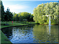
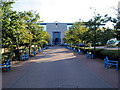
Office park lake and sitting area.
The estate is extremely well maintained.
Image: © Steve Fareham
Taken: 18 Jul 2007
0.09 miles
2
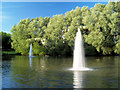
Fountains in man made lake.
There are 3 man made lakes on the estate.
Image: © Steve Fareham
Taken: 18 Jul 2007
0.12 miles
4
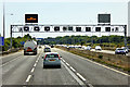
Overhead Sign Gantry, Southbound M5 near Almondsbury
Image: © David Dixon
Taken: 21 Jul 2018
0.14 miles
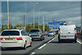
5
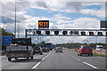
M5 merging traffic after junction 16
Heading south west near Patchway.
Image: © J.Hannan-Briggs
Taken: 22 Sep 2015
0.14 miles
8
South Gloucestershire : M5 Motorway
The M5 Motorway between Junction 17 (Cribbs Causeway) and Junction 16.
Image: © Lewis Clarke
Taken: 30 Sep 2018
0.16 miles
9

South Gloucestershire : M5 Motorway
The M5 Motorway between Junction 17 (Cribbs Causeway) and Junction 16.
Image: © Lewis Clarke
Taken: 30 Sep 2018
0.17 miles