IMAGES TAKEN NEAR TO
Pines Lane, BRISTOL, BS32 4PP
Introduction
This page details the photographs taken nearby to Pines Lane, BS32 4PP by members of the Geograph project.
The Geograph project started in 2005 with the aim of publishing, organising and preserving representative images for every square kilometre of Great Britain, Ireland and the Isle of Man.

There are currently over 7.5m images from over14,400 individuals and you can help contribute to the project by visiting https://www.geograph.org.uk
Image Map
Images are licensed for reuse under creativecommons.org/licenses/by-sa/2.0
Notes
- Clicking on the map will re-center to the selected point.
- The higher the marker number, the further away the image location is from the centre of the postcode.
Image Listing (4 Images Found)
Images are licensed for reuse under creativecommons.org/licenses/by-sa/2.0
Image
Details
Distance
3
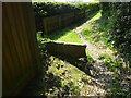
Stone Stile, Old Down GS9524
On Gloucestershire footpath OOL/39/10 looking West. The view East is Image
Image: © Mr Red
Taken: 22 May 2023
0.23 miles
4
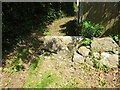
Stone Stile, Old Down GS9524
On Gloucestershire footpath OOL/39/10 looking East. The view West is Image
Image: © Mr Red
Taken: 22 May 2023
0.23 miles