IMAGES TAKEN NEAR TO
Hardy Lane, BRISTOL, BS32 4LN
Introduction
This page details the photographs taken nearby to Hardy Lane, BS32 4LN by members of the Geograph project.
The Geograph project started in 2005 with the aim of publishing, organising and preserving representative images for every square kilometre of Great Britain, Ireland and the Isle of Man.

There are currently over 7.5m images from over14,400 individuals and you can help contribute to the project by visiting https://www.geograph.org.uk
Image Map
Images are licensed for reuse under creativecommons.org/licenses/by-sa/2.0
Notes
- Clicking on the map will re-center to the selected point.
- The higher the marker number, the further away the image location is from the centre of the postcode.
Image Listing (5 Images Found)
Images are licensed for reuse under creativecommons.org/licenses/by-sa/2.0
Image
Details
Distance
1
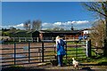
Tockington : Stables
Stables off Moor Lane.
Image: © Lewis Clarke
Taken: 14 Mar 2022
0.19 miles
2
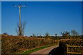
Tockington : Moor Lane
Looking along Moor Lane.
Image: © Lewis Clarke
Taken: 14 Mar 2022
0.21 miles
3

Tockington : Moor Lane
Looking along Moor Lane.
Image: © Lewis Clarke
Taken: 14 Mar 2022
0.22 miles
4
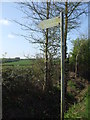
A faded path
The sign is in worse shape than the footpath, fortunately.
Image: © Neil Owen
Taken: 28 Mar 2019
0.23 miles
5
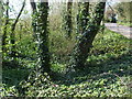
Once it was Miles Well
This leafy but rather dry spot is the site of the old Miles Well. But it is marked on nineteenth century maps as St Michael's Well, before assuming the latter name. A slight trickle of water runs downhill to the village of Tockington.
Image: © Neil Owen
Taken: 28 Mar 2019
0.24 miles