IMAGES TAKEN NEAR TO
Gloucester Road, BRISTOL, BS32 4HB
Introduction
This page details the photographs taken nearby to Gloucester Road, BS32 4HB by members of the Geograph project.
The Geograph project started in 2005 with the aim of publishing, organising and preserving representative images for every square kilometre of Great Britain, Ireland and the Isle of Man.

There are currently over 7.5m images from over14,400 individuals and you can help contribute to the project by visiting https://www.geograph.org.uk
Image Map
Images are licensed for reuse under creativecommons.org/licenses/by-sa/2.0
Notes
- Clicking on the map will re-center to the selected point.
- The higher the marker number, the further away the image location is from the centre of the postcode.
Image Listing (24 Images Found)
Images are licensed for reuse under creativecommons.org/licenses/by-sa/2.0
Image
Details
Distance
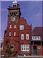
1
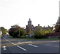
Tower House Almondsbury from the A38 going North.
I am reliably told this is now a private house and was formerly a maternity hospital.
Image: © Steve Fareham
Taken: 10 Sep 2007
0.03 miles
2
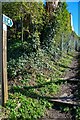
Almonsbury : Footpath
A footpath from The Scop to Gloucester Road.
Image: © Lewis Clarke
Taken: 14 Mar 2022
0.04 miles
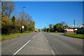
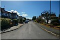
3
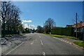
Almondsbury : Gloucester Road A38
Looking along Gloucester Road.
Image: © Lewis Clarke
Taken: 14 Mar 2022
0.05 miles
4
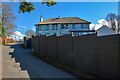
Almondsbury : The Scop
Looking along The Scop.
Image: © Lewis Clarke
Taken: 14 Mar 2022
0.07 miles
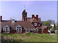
5
Tower House, Almondsbury
This late 19th century community hall was converted to 'Almondsbury Hospital' in the early 20th century and continued to be used as such until 1996. Tower House was then taken into private ownership and converted into a modern day dwelling.
Image: © Adam Zirps
Taken: 8 Apr 2007
0.07 miles
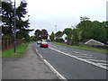
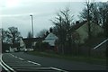
7
Almondsbury : Gloucester Road A38
Looking along the A38.
Image: © Lewis Clarke
Taken: 14 Mar 2022
0.08 miles
9
Almondsbury : Crantock Drive
Looking along Crantock Drive off Florence Park.
Image: © Lewis Clarke
Taken: 14 Mar 2022
0.09 miles
10
Telephone box beside Gloucester Road
This telephone box and the nearby postbox are on the A38 Gloucester Road where it skirts the eastern edge of Almondsbury.
Image: © Ruth Riddle
Taken: 6 Jan 2012
0.10 miles