IMAGES TAKEN NEAR TO
Lime Kiln Gardens, BRISTOL, BS32 0DB
Introduction
This page details the photographs taken nearby to Lime Kiln Gardens, BS32 0DB by members of the Geograph project.
The Geograph project started in 2005 with the aim of publishing, organising and preserving representative images for every square kilometre of Great Britain, Ireland and the Isle of Man.

There are currently over 7.5m images from over14,400 individuals and you can help contribute to the project by visiting https://www.geograph.org.uk
Image Map
Images are licensed for reuse under creativecommons.org/licenses/by-sa/2.0
Notes
- Clicking on the map will re-center to the selected point.
- The higher the marker number, the further away the image location is from the centre of the postcode.
Image Listing (24 Images Found)
Images are licensed for reuse under creativecommons.org/licenses/by-sa/2.0
Image
Details
Distance
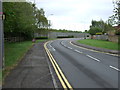
4
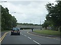
Woodlands Lane beside M4
Woodlands Lane passing the wooden fence which separates it from the westbound carriageway of the M4.
Image: © Ruth Riddle
Taken: 22 Jun 2012
0.15 miles
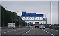
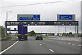
5
South Gloucestershire : The M4 Motorway
Heading along the M4 Motorway towards the turn off to the South West along the M5.
Image: © Lewis Clarke
Taken: 1 Feb 2013
0.15 miles

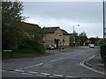
7
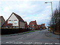
Foxfield Avenue
Looking north up Foxfield from Bowsland Way.The first road on the left just visible is Rush Close
Image: © Nigel Mykura
Taken: 17 Mar 2013
0.15 miles
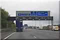
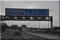
9

South Gloucestershire : M4 Motorway
The M4 Motorway seen after joining from the M5 on a busy afternoon.
Image: © Lewis Clarke
Taken: 23 Mar 2018
0.16 miles