IMAGES TAKEN NEAR TO
Howard Road, BRISTOL, BS3 1QH
Introduction
This page details the photographs taken nearby to Howard Road, BS3 1QH by members of the Geograph project.
The Geograph project started in 2005 with the aim of publishing, organising and preserving representative images for every square kilometre of Great Britain, Ireland and the Isle of Man.

There are currently over 7.5m images from over14,400 individuals and you can help contribute to the project by visiting https://www.geograph.org.uk
Image Map
Images are licensed for reuse under creativecommons.org/licenses/by-sa/2.0
Notes
- Clicking on the map will re-center to the selected point.
- The higher the marker number, the further away the image location is from the centre of the postcode.
Image Listing (427 Images Found)
Images are licensed for reuse under creativecommons.org/licenses/by-sa/2.0
Image
Details
Distance
1
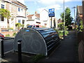
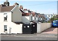
Bike hangar on Howard Road
One of fifteen such bike shelters to be rented in suburban Bristol, each holding six machines. They have generated a large waiting list, despite costing £36 per annum, plus costs.
Image: © Neil Owen
Taken: 31 May 2021
0.03 miles
2
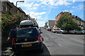
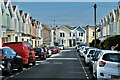
Osborne Road, Southville, Bristol
Osborne Road climbs up from Coronation Road and the River Avon before bearing left into Pembroke Road. Allington Road goes off to the right.
Image: © Eirian Evans
Taken: 1 Aug 2010
0.03 miles
3
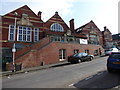
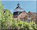
Southville Centre, Beauley Street
The Southville Centre on Beauley Road is a grade 2 listed building that started out as a school in 1898. Since 1991 it has been a community centre. This has been asset transferred to Southville Community Development Association (SCDA).The building includes a café, nursery, rooms for hire, and a venue for the NHS Blood Donation Service
Image: © Eirian Evans
Taken: 22 Feb 2018
0.05 miles
5
Southville Centre
Beauley Road, Southville
Image: © Anthony O'Neil
Taken: 22 May 2021
0.05 miles
6
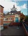
The Southville Centre, Bristol
Important social/arts/information centre serving Southville and Bedminster. Also has a cafe providing daily meals and snacks to locals.
Image: © Anthony O'Neil
Taken: 19 Nov 2010
0.05 miles
7
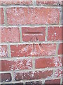
Ordnance Survey Cut Mark
This OS cut mark can be found on the old school wall, NE side of Beauley Road. It marks a point 15.795m above mean sea level.
Image: © Adrian Dust
Taken: 14 Mar 2016
0.05 miles
8

Beauley Road benchmark
A cutmark, dating from the post-war era and listed in the Benchmark Database: https://www.bench-marks.org.uk/bm74189 . The wall is a relatively new one, being part of the conversion of the old school into residential use. See Image] for a wider view.
Image: © Neil Owen
Taken: 3 Sep 2021
0.05 miles
9
New houses on the old school
The corner of Beauley Road and Dalston Road: what were the old Bristol School Board buildings were converted into residential use and a community centre.
Originally a school complex designed in 1895 by Edward Gabriel, it was opened by Ashton Park Board and featured an early layout where classrooms surrounded a central hall.
See Image] for a benchmark on the wall.
Image: © Neil Owen
Taken: 3 Sep 2021
0.05 miles