IMAGES TAKEN NEAR TO
Hamilton Road, BRISTOL, BS3 1PB
Introduction
This page details the photographs taken nearby to Hamilton Road, BS3 1PB by members of the Geograph project.
The Geograph project started in 2005 with the aim of publishing, organising and preserving representative images for every square kilometre of Great Britain, Ireland and the Isle of Man.

There are currently over 7.5m images from over14,400 individuals and you can help contribute to the project by visiting https://www.geograph.org.uk
Image Map
Images are licensed for reuse under creativecommons.org/licenses/by-sa/2.0
Notes
- Clicking on the map will re-center to the selected point.
- The higher the marker number, the further away the image location is from the centre of the postcode.
Image Listing (330 Images Found)
Images are licensed for reuse under creativecommons.org/licenses/by-sa/2.0
Image
Details
Distance
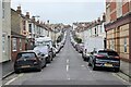
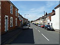
3
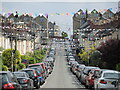
Hamilton Road
Many of Ashton's Victorian terraces retain their linear character.
Image: © Neil Owen
Taken: 31 May 2021
0.04 miles
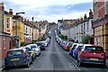
5
Leighton Street has something to celebrate
Not sure what though, as few other roads have the bunting out.
Image: © Neil Owen
Taken: 31 May 2021
0.05 miles
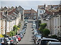
6
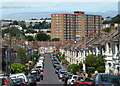
View across Bedminster and Southville, Bristol
In the far distance can be seen the terraces of Clifton and a glimpse of the top of the Clifton Suspension Bridge. This perspective illustrates how hilly parts of Bedminster really are.
Image: © Anthony O'Neil
Taken: 9 Jul 2010
0.07 miles
7

Ordnance Survey Cut Mark
This OS cut mark can be found on No31 Raleigh Road. It marks a point 8.943m above mean sea level.
Image: © Adrian Dust
Taken: 23 Dec 2019
0.07 miles
8
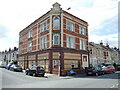
Reusing an old office
When this part of Bristol was built and developed around the turn of the nineteenth century, this large and somewhat incongruous block was included. Today it is a residential building, but see Image] for a clue as to some previous owners.
Image: © Neil Owen
Taken: 22 Jun 2021
0.07 miles
9
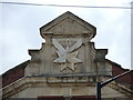
Taking over after a takeover
The large building at the junction of Raleigh Road and Hamilton Road is out of context with all the typical terrace houses. At its apex is a familiar emblem - that of and eagle and a star - presumably that of the well-known (but now defunct) insurance firm. However, they were founded in 1904 and the date stone shows an earlier one. It's not easy to identify the previous sign.
See Image] for a wider look at the offices now converted into residential.
Image: © Neil Owen
Taken: 22 Jun 2021
0.07 miles
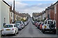
10
View of Raleigh Road, Bedminster
In the distance are large buildings which once formed part of the WD & HO Wills tobacco empire. These houses would have been built to accommodate their employees near to their place of work - something which eliminated today's imperative to commute.
Image: © Anthony O'Neil
Taken: 9 Jul 2010
0.07 miles