IMAGES TAKEN NEAR TO
Coronation Road, BRISTOL, BS3 1FD
Introduction
This page details the photographs taken nearby to Coronation Road, BS3 1FD by members of the Geograph project.
The Geograph project started in 2005 with the aim of publishing, organising and preserving representative images for every square kilometre of Great Britain, Ireland and the Isle of Man.

There are currently over 7.5m images from over14,400 individuals and you can help contribute to the project by visiting https://www.geograph.org.uk
Image Map
Images are licensed for reuse under creativecommons.org/licenses/by-sa/2.0
Notes
- Clicking on the map will re-center to the selected point.
- The higher the marker number, the further away the image location is from the centre of the postcode.
Image Listing (1077 Images Found)
Images are licensed for reuse under creativecommons.org/licenses/by-sa/2.0
Image
Details
Distance
1
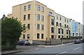
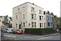
Houses of Bristol (27)
Coronation Road
Image: © Anthony O'Neil
Taken: 18 Apr 2020
0.00 miles
2
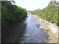
Looking along the New Cut from Goal Ferry Bridge
The New Cut at low tide, seen from Goal Ferry Bridge.
Image: © Linda Bailey
Taken: 19 Sep 2006
0.02 miles
3
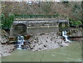
Storm drains in the south bank of the Avon New Cut
Carry the outflow of streams like the Malago which were tributaries of the Avon before the Cut was completed in 1809. These 'hidden' rivers are now for the most part diverted through channels and culverts beneath Bedminster and Southville.
Image: © Anthony O'Neil
Taken: 24 Jan 2011
0.02 miles
4
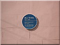
Russ Conway
Popular in the 50's and early 60's, Conway lived for a time at 2 Dean Lane, Southville, where this plaque can be found.
Image: © Chris Heaton
Taken: 18 Mar 2007
0.03 miles
5
Houses of Bristol (26)
Coronation Road
Image: © Anthony O'Neil
Taken: 18 Apr 2020
0.04 miles
6

Experiencing fluctuations
An interesting piece of 'art'. Did it have anything to do with the waterworks sign or is something else worrying it?
Image: © Neil Owen
Taken: 22 May 2016
0.04 miles
7
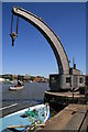
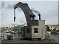
Steamy Bristol
Bristol Industrial Museum own the Fairbairn type steam crane and the tug Mayflower, both visible in this view.
Image: © Chris Allen
Taken: 15 Jul 2006
0.05 miles
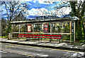
9
Wapping Wharf bus stop
Cumberland Road
Image: © Anthony O'Neil
Taken: 20 Apr 2020
0.05 miles
10
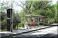
Shelter (4)
Wapping Wharf stop: M2 Metrobus route, Cumberland Road
Image: © Anthony O'Neil
Taken: 19 Mar 2023
0.05 miles