IMAGES TAKEN NEAR TO
Coronation Road, BRISTOL, BS3 1AS
Introduction
This page details the photographs taken nearby to Coronation Road, BS3 1AS by members of the Geograph project.
The Geograph project started in 2005 with the aim of publishing, organising and preserving representative images for every square kilometre of Great Britain, Ireland and the Isle of Man.

There are currently over 7.5m images from over14,400 individuals and you can help contribute to the project by visiting https://www.geograph.org.uk
Image Map
Images are licensed for reuse under creativecommons.org/licenses/by-sa/2.0
Notes
- Clicking on the map will re-center to the selected point.
- The higher the marker number, the further away the image location is from the centre of the postcode.
Image Listing (1077 Images Found)
Images are licensed for reuse under creativecommons.org/licenses/by-sa/2.0
Image
Details
Distance
1
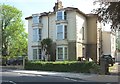
Houses of Bristol (28)
Coronation Road
Image: © Anthony O'Neil
Taken: 23 Apr 2020
0.00 miles
2
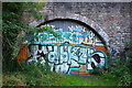
Underneath the arches
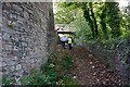
This graffitied entrance conceals a passageway which used to lead beneath Coronation Road and gave access to coal supplies from the old Deansgate Lane Colliery which were to be loaded onto vessels in the Avon Cut, at the point where the Gaol Ferry also used to operate.
Image: © Anthony O'Neil
Taken: 9 Jul 2014
0.01 miles
3

Uncyphered box outsied St Paul's
A blank letterbox mounted in the wall next to the church; normally the reigning monarch's initials are prominent. The box is a Smith and Hawkes of Birmingham product. See Image] for a location view.
Image: © Neil Owen
Taken: 3 Sep 2021
0.02 miles
4

Old letterbox on Coronation Road
A box has been here since the mid 1800s, and it is unusual in that it does not bear the reigning monarch's cypher. See Image
Image: © Neil Owen
Taken: 3 Sep 2021
0.02 miles
5
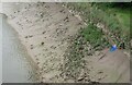
All sorts of junk left at low tide in the Avon
Bits of bikes, shopping trolleys, a ladder, a fork and a sleeping bag all left for the river gods
Image: © Eirian Evans
Taken: 9 Jun 2022
0.02 miles
7
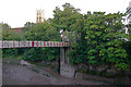
Gaol Ferry ramp
Steep incline where the access track to the old ferry used to be before the nearby iron bridge (just visible) was constructed across the New Cut (itself completed in 1809). The land on this side of the Cut is artificially high because the vast amount of spoil (from the excavation of the new waterway) was deposited predominantly on the southern bank.
Image: © Anthony O'Neil
Taken: 9 Jul 2014
0.02 miles
8
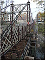
Getting to the detail
Gaol Ferry Bridge has (finally) been shut for inspection and maintenance. It appears that the problems are a bit worse than were first thought.
Image: © Neil Owen
Taken: 7 Dec 2022
0.02 miles
9
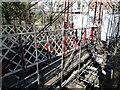
Some of the work is done
Gaol Ferry Bridge was built in 1935 and, somewhat surprisingly, is not a swing bridge - unlike Vauxhall Bridge downstream. It was thought unnecessary as marine traffic on the New Cut was diminishing. Even so, the steel lattice structure is now in a parlous state and requiring urgent repairs. What was expected to be a tough job has proved even tougher since the covers were removed.
Having removed a lot of the decking and the supports, a plastic 'tent' has been put in place whilst paint-stripping and rust blasting is carried out and materials prevented from dropping into the river below. Some of the steel has already been treated this way.
Currently the timescale has been extended and the costs projected to be around £1.5 million.
Image: © Neil Owen
Taken: 14 Mar 2023
0.02 miles
10
Steps to the Cut
Vestiges of the old ferry landing beneath Gaol Ferry Bridge.
Image: © Anthony O'Neil
Taken: 9 Jul 2014
0.02 miles