IMAGES TAKEN NEAR TO
Coronation Road, BRISTOL, BS3 1AA
Introduction
This page details the photographs taken nearby to Coronation Road, BS3 1AA by members of the Geograph project.
The Geograph project started in 2005 with the aim of publishing, organising and preserving representative images for every square kilometre of Great Britain, Ireland and the Isle of Man.

There are currently over 7.5m images from over14,400 individuals and you can help contribute to the project by visiting https://www.geograph.org.uk
Image Map
Images are licensed for reuse under creativecommons.org/licenses/by-sa/2.0
Notes
- Clicking on the map will re-center to the selected point.
- The higher the marker number, the further away the image location is from the centre of the postcode.
Image Listing (1035 Images Found)
Images are licensed for reuse under creativecommons.org/licenses/by-sa/2.0
Image
Details
Distance
1
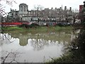
Bristol General Hospital from across the Avon
Image: © FollowMeChaps
Taken: 4 Jan 2006
0.00 miles
2
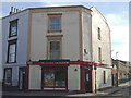
The Little Grosvenor
A traditional and fairly old local boozer in an area that was not exactly short of them in the nineteenth century.
Image: © Neil Owen
Taken: 14 Sep 2019
0.01 miles
3
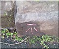
Ordnance Survey Cut Mark
This OS cut mark can be found on the gatepost of the Zion Chapel on Coronation Road.
Image: © Adrian Dust
Taken: 18 Jan 2020
0.01 miles
4
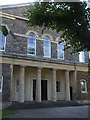
The old Zion Chapel
The Zion Congregational Chapel was built in 1829, with seats for 500 worshippers and a small graveyard. A Sunday school was added next door soon after and served the populace until closure in 1984. It is now the premises of a commercial organisation involved with furniture manufacture.
Image: © Neil Owen
Taken: 14 Sep 2019
0.01 miles
7

Don't go too far!
Some helpful signage on Bedminster Bridge.
Image: © Neil Owen
Taken: 14 Mar 2023
0.02 miles
8
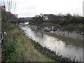
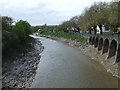
River Avon, New Cut, Bristol
The River Avon, New Cut, looking east towards Bedminster bridge as the tide flows strongly out.
Image: © Dr Duncan Pepper
Taken: 24 Dec 2007
0.02 miles
9
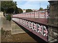
Reusing rope
Bedminster Bridge is a modern road bridge, recently rebuilt in 1998. However, originally it was a single crossing (the modern road system has two in a roundabout fashion) and was known as Harford's Bridge. That was constructed in the early 1800s as the New Cut was dug as part of the grand scheme of Bristol's Floating Harbour. Harford's was a shallow cast-iron bridge, made in Coalbrookdale, and featured some fine 'rope' details that has been retained - see Image
However, the original bridge was not that strong and was damaged by the ship 'Fanny Chapman' in 1860. Horse-drawn traffic was alarmed at the state of it and led to a major rebuild in 1880-82.
Image: © Neil Owen
Taken: 14 Sep 2019
0.04 miles
10
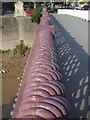
Iron rope
Harford's Bridge dates from around 1805 onwards when the New Cut was dug here and effectively cut off Bedminster from the rest of Redcliffe and Bristol in general. Made by the Coalbrookdale Company in cast iron, this 'ropework' is a fine example from the original version. Having been rebuilt twice since, this detail has been thankfully retained. See Image] for a wider view.
Image: © Neil Owen
Taken: 14 Sep 2019
0.04 miles