IMAGES TAKEN NEAR TO
Copse Road, BRISTOL, BS31 3TH
Introduction
This page details the photographs taken nearby to Copse Road, BS31 3TH by members of the Geograph project.
The Geograph project started in 2005 with the aim of publishing, organising and preserving representative images for every square kilometre of Great Britain, Ireland and the Isle of Man.

There are currently over 7.5m images from over14,400 individuals and you can help contribute to the project by visiting https://www.geograph.org.uk
Image Map
Images are licensed for reuse under creativecommons.org/licenses/by-sa/2.0
Notes
- Clicking on the map will re-center to the selected point.
- The higher the marker number, the further away the image location is from the centre of the postcode.
Image Listing (11 Images Found)
Images are licensed for reuse under creativecommons.org/licenses/by-sa/2.0
Image
Details
Distance
1
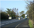
2010 : A4 nearly on the approach to Keynsham
Saltford about half a mile behind.
Horace Bachelor (1898-1977) with his "Famous Infra Draw Method" http://en.wikipedia.org/wiki/Horace_Batchelor lived along here, he had a nice house.
Image: © Maurice Pullin
Taken: 5 Feb 2010
0.04 miles
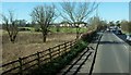
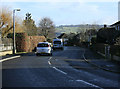
3
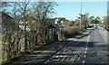
Bus stop on the Bath Road
The Copse Road Bus Stop on the A4 between Saltford and Keynsham.
Image: © Derek Harper
Taken: 24 Feb 2016
0.05 miles
4
2010 : A4 leaving Saltford to the north west
About a mile to Keynsham, then Bristol.
During the 1970's there was a 40mph limit right through Saltford, now it is 30. Far more sensible.
Image: © Maurice Pullin
Taken: 5 Feb 2010
0.11 miles
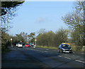
5
Bath Road
The A4 just northwest of Saltford, and approaching the scene in Image; the 40mph signs can be seen ahead. The houses ahead are at Copse Road.
Image: © Derek Harper
Taken: 24 Feb 2016
0.12 miles
6
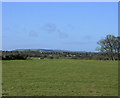
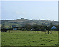
2010 : West from the A4 near Saltford
The large field in the foreground takes the eye almost to the edge of the grid square.
Further over housing south of Keynsham can be seen, and beyond that, somewhat foreshortened, lies Dundry Hill. In the original image it is possible to see the tower of Dundry Church on the horizon.
Image: © Maurice Pullin
Taken: 5 Feb 2010
0.13 miles
7
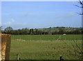
2010 : North from the A4 near Saltford
Looking in the direction of Bitton with a field in the foreground.
Bitton Hill is in the background, the River Avon is out of sight this side of it.
Image: © Maurice Pullin
Taken: 5 Feb 2010
0.14 miles
8
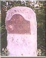
Old Milestone by the A4, Bath Road, Keynsham Parish
Metal plate attached to stone post by the A4, in parish of KEYNSHAM (BATH AND NORTH EAST SOMERSET District), Bath Road, just West of Saltford, before Longreach Hotel, on grass verge just before Saltford sign, on North side of road. Bristol iron plate, erected by the Bristol turnpike trust in the 19th century.
Inscription reads:- : 6 / MILES / TO / BRISTOL :
Grade II Listed. List Entry Number: 1384591 see https://historicengland.org.uk/listing/the-list/list-entry/1384591
Milestone Society National ID: SO_BABR06.
Image: © A Brackenbury
Taken: 1 Jun 2001
0.14 miles
9
2010 : East from the A4 near Saltford
North west of the village.
Houses on the northern edge of Saltford can be seen and in the distance, although it's trees are bare of leaves, Kelston Round Hill Image still dominates.
Image: © Maurice Pullin
Taken: 5 Feb 2010
0.18 miles
10
2010 : Grange Road, Saltford
On the north western edge of the housing estate.
A pleasant, mostly post war, housing estate. The hill facing is on the other side of the River Avon near North Stoke.
Image: © Maurice Pullin
Taken: 5 Feb 2010
0.21 miles