IMAGES TAKEN NEAR TO
Montague Road, BRISTOL, BS31 3LL
Introduction
This page details the photographs taken nearby to Montague Road, BS31 3LL by members of the Geograph project.
The Geograph project started in 2005 with the aim of publishing, organising and preserving representative images for every square kilometre of Great Britain, Ireland and the Isle of Man.

There are currently over 7.5m images from over14,400 individuals and you can help contribute to the project by visiting https://www.geograph.org.uk
Image Map
Images are licensed for reuse under creativecommons.org/licenses/by-sa/2.0
Notes
- Clicking on the map will re-center to the selected point.
- The higher the marker number, the further away the image location is from the centre of the postcode.
Image Listing (9 Images Found)
Images are licensed for reuse under creativecommons.org/licenses/by-sa/2.0
Image
Details
Distance
1
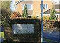
2010 : Sign for Manor Lawns , Saltford
At the junction of Manor Road and Montague Road.
The manor in question is probably Keynsham Manor a few hundred yards on.
Was nearly tempted to get the wire brush out and give it a going over.
Image: © Maurice Pullin
Taken: 5 Feb 2010
0.05 miles
2
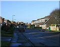
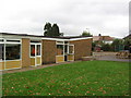
2010 : Montague Road, Saltford
At the southern edge of the post-war housing estate. Quite pleasant as they go.
Image: © Maurice Pullin
Taken: 5 Feb 2010
0.05 miles
3
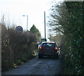
2010 : A dark and mysterious lane south of Saltford
Overgrown hedgerows add their contribution. The green van beyond appears to be delivering or repairing windows and doors to a house being done up for sale.
Image: © Maurice Pullin
Taken: 5 Feb 2010
0.07 miles
4
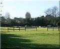
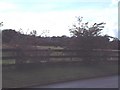
2010 : Pasture seen from Manor Road, Saltford
The pen and shelter beyond the fence appears to be for sheep.
Image: © Maurice Pullin
Taken: 5 Feb 2010
0.10 miles
5
Horse paddocks and farmland viewed from Manor Road
Image: © Elizabeth Spincer
Taken: Unknown
0.11 miles
6
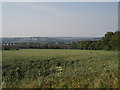
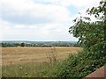
Saltford through the fields
At the bottom of this large field the southern housing estate of the village of Saltford can be seen.
Image: © Sharon Loxton
Taken: 17 Jun 2006
0.16 miles
8
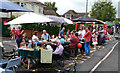
Claverton Rd, Saltford.
Taken during the Queen's Jubilee
Image: © Rick Crowley
Taken: 3 Jun 2012
0.22 miles
9
The Southern border of Saltford with Farmland Green Belt
Although Ashton Hill is not particularly high (116 metres) there are a surprising number of good views around here.
Image: © Dr Duncan Pepper
Taken: 17 Aug 2015
0.23 miles