IMAGES TAKEN NEAR TO
Mansel Close, BRISTOL, BS31 3LE
Introduction
This page details the photographs taken nearby to Mansel Close, BS31 3LE by members of the Geograph project.
The Geograph project started in 2005 with the aim of publishing, organising and preserving representative images for every square kilometre of Great Britain, Ireland and the Isle of Man.

There are currently over 7.5m images from over14,400 individuals and you can help contribute to the project by visiting https://www.geograph.org.uk
Image Map
Images are licensed for reuse under creativecommons.org/licenses/by-sa/2.0
Notes
- Clicking on the map will re-center to the selected point.
- The higher the marker number, the further away the image location is from the centre of the postcode.
Image Listing (9 Images Found)
Images are licensed for reuse under creativecommons.org/licenses/by-sa/2.0
Image
Details
Distance
1
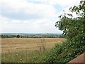
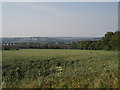
The Southern border of Saltford with Farmland Green Belt
Although Ashton Hill is not particularly high (116 metres) there are a surprising number of good views around here.
Image: © Dr Duncan Pepper
Taken: 17 Aug 2015
0.10 miles
2
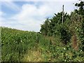
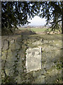
Permissive Path no longer allowed
This used to be a Permissive Path but the access has been withdrawn by the landowner.
Image: © don cload
Taken: 26 Jul 2014
0.13 miles
3
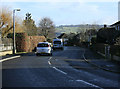
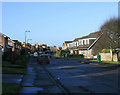
2010 : Grange Road, Saltford
On the north western edge of the housing estate.
A pleasant, mostly post war, housing estate. The hill facing is on the other side of the River Avon near North Stoke.
Image: © Maurice Pullin
Taken: 5 Feb 2010
0.15 miles
4
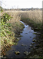
Stream near Keynsham Manor
A small watercourse close to the ancient manor house. A nearby sign on a post reveals the campaign to achieve more footpaths in the area, However, the grants supplied to landowners were greatly reduced in recent years and the local walkers are trying to raise the considerable costs to compensate them.
Image: © Neil Owen
Taken: 23 Feb 2018
0.19 miles
5
2010 : Montague Road, Saltford
At the southern edge of the post-war housing estate. Quite pleasant as they go.
Image: © Maurice Pullin
Taken: 5 Feb 2010
0.19 miles
6
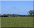
Saltford through the fields
At the bottom of this large field the southern housing estate of the village of Saltford can be seen.
Image: © Sharon Loxton
Taken: 17 Jun 2006
0.20 miles
7
Conservation walks along Manor Road
The area around the woodland is popular with walkers and there are moves afoot to open up more of the countryside to more paths.
Image: © Neil Owen
Taken: 23 Feb 2018
0.23 miles
8
2010 : West from the A4 near Saltford
The large field in the foreground takes the eye almost to the edge of the grid square.
Further over housing south of Keynsham can be seen, and beyond that, somewhat foreshortened, lies Dundry Hill. In the original image it is possible to see the tower of Dundry Church on the horizon.
Image: © Maurice Pullin
Taken: 5 Feb 2010
0.24 miles
9
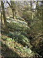
Snowdrops in Manor Road Community Woodlands
A little seasonal colour and beauty.
Image: © Neil Owen
Taken: 23 Feb 2018
0.24 miles