IMAGES TAKEN NEAR TO
Bath Road, BRISTOL, BS31 3JU
Introduction
This page details the photographs taken nearby to Bath Road, BS31 3JU by members of the Geograph project.
The Geograph project started in 2005 with the aim of publishing, organising and preserving representative images for every square kilometre of Great Britain, Ireland and the Isle of Man.

There are currently over 7.5m images from over14,400 individuals and you can help contribute to the project by visiting https://www.geograph.org.uk
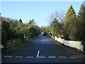
Image Map
Images are licensed for reuse under creativecommons.org/licenses/by-sa/2.0
Notes
- Clicking on the map will re-center to the selected point.
- The higher the marker number, the further away the image location is from the centre of the postcode.
Image Listing (61 Images Found)
Images are licensed for reuse under creativecommons.org/licenses/by-sa/2.0
Image
Details
Distance
1
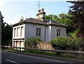
Tollhouse by the A4, Bath Road, Saltford
Tollhouse by the A4, in parish of Saltford (Bath and North East Somerset District), Old Turnpike, No. 532, Bath Road, BS31.
Grade II listed.
List Entry Number: 1384651 https://historicengland.org.uk/listing/the-list/list-entry/1384651
Surveyed
Milestone Society National ID: AV.SAL
Image: © Alan Rosevear
Taken: Unknown
0.00 miles
2
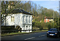
2010 : Turnpike house in the Palladian style
On the A4 east of Saltford.
"The term "turnpike" originates from the similarity of the gate used to control access to the road, to the barriers once used to defend against attack by cavalry. The turnpike consisted of a row of pikes or bars, each sharpened at one end, and attached to horizontal members which were secured at one end to an upright pole or axle, which could be rotated to open or close the gate."
The above was copied from: http://en.wikipedia.org/wiki/Turnpike_trusts_in_the_United_Kingdom
Image: © Maurice Pullin
Taken: 5 Feb 2010
0.01 miles
3
2010 : Front of Turnpike House on A4
At the bottom of Saltford Hill.
This is a close up of the house seen in Image]
The crash barrier is unfortunate but protects this valuable old building from passing traffic.
Image: © Maurice Pullin
Taken: 5 Feb 2010
0.01 miles
4

2010 : Avon Valley Cars on the M4
"Cars bought for cash."
Yes, that is the usual way, wouldn't want to exchange mine for garden furniture and sheep could be a bit awkward.
Image: © Maurice Pullin
Taken: 5 Feb 2010
0.03 miles
5
2010 : Avon County Rowing Club, the back entrance
The main entrance is on the river and far more impressive.
"Avon County Rowing Club was formed in 1973, following a merger of the former Avon and Bristol clubs. This ended a tradition of friendly rivalry, stretching back to the previous century, between oarsmen training in the colours of a succession of clubs based at Saltford."
The above was copied from: http://www.avoncountyrowingclub.org.uk/page14g.html
Image: © Maurice Pullin
Taken: 5 Feb 2010
0.06 miles
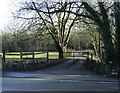
6
2010 : The Glen, Saltford
A private road off the A4 near the bottom of Saltford Hill.
Note the sensible 15 mph speed limit with speed bumps.
Image: © Maurice Pullin
Taken: 5 Feb 2010
0.08 miles
7
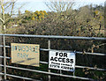
2010 : Bring your own scrub cutter
Not the main entrance to Barnsdale Park.
Seen from the A4.
Image: © Maurice Pullin
Taken: 5 Feb 2010
0.08 miles
8
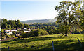
The Glen, Saltford, near Bath
A private cul-de-sac of mainly large residential properties just off the A4 road. Picture taken from Saltford Golf Course.
Image: © Rick Crowley
Taken: 12 May 2020
0.10 miles
9
River Avon at Saltford
Rowing at Saltford. The boathouses are on the edge of Image
Image: © Pierre Terre
Taken: 20 May 2006
0.12 miles
10
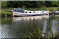
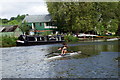
The River Avon
A Dutch barge moored along the south bank of the River Avon.
Image: © Sharon Loxton
Taken: 23 Sep 2007
0.13 miles