IMAGES TAKEN NEAR TO
Bath Road, BRISTOL, BS31 3JN
Introduction
This page details the photographs taken nearby to Bath Road, BS31 3JN by members of the Geograph project.
The Geograph project started in 2005 with the aim of publishing, organising and preserving representative images for every square kilometre of Great Britain, Ireland and the Isle of Man.

There are currently over 7.5m images from over14,400 individuals and you can help contribute to the project by visiting https://www.geograph.org.uk
Image Map
Images are licensed for reuse under creativecommons.org/licenses/by-sa/2.0
Notes
- Clicking on the map will re-center to the selected point.
- The higher the marker number, the further away the image location is from the centre of the postcode.
Image Listing (116 Images Found)
Images are licensed for reuse under creativecommons.org/licenses/by-sa/2.0
Image
Details
Distance
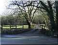
1
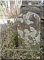
Initialed stone by the garage
An odd stone close to the small group of garages in Saltford, bearing what looks like the initials 'J.B.' It stands on the entrance opposite a similar stone with different initials - see Image] for the latter and Image] for a wider view.
Image: © Neil Owen
Taken: 7 Mar 2018
0.04 miles
2
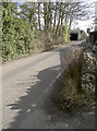
Hairpin into The Shallows
The turn into The Shallows off the A4 is a really tight one coming from Keynsham. The road leads under the railway line and in so doing passes this little row of garages, where a marker stone marks the entrance - see Image] for a closer look.
Image: © Neil Owen
Taken: 7 Mar 2018
0.04 miles
3
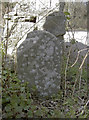
Initialed stone
An odd piece of stonework just from the junction with the Bath Road, marking what appears to be the entrance to a garage. There is another, similar opposite - see Image] for a look and Image] for a wider view. Local boundaries do not appear to run through here so the supposition is that they are property markers. The initials appear to be 'P.P.'
Image: © Neil Owen
Taken: 7 Mar 2018
0.05 miles
4
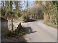
The start of The Shallows
The road off the A4 Bath Road swings sharply then turns again to go under the main railway line. As it does so, there are a small group of garages or stores. Marking the entrance are two initialed stones - see Image] for the one in shot here.
Image: © Neil Owen
Taken: 7 Mar 2018
0.05 miles
5
2010 : Avon County Rowing Club, the back entrance
The main entrance is on the river and far more impressive.
"Avon County Rowing Club was formed in 1973, following a merger of the former Avon and Bristol clubs. This ended a tradition of friendly rivalry, stretching back to the previous century, between oarsmen training in the colours of a succession of clubs based at Saltford."
The above was copied from: http://www.avoncountyrowingclub.org.uk/page14g.html
Image: © Maurice Pullin
Taken: 5 Feb 2010
0.06 miles
6
Railway embankment, Saltford
Close beside the river Avon, this embankment appears to have suffered land slip in the recent past, as it has acquired steel pilings.
Image: © Dr Duncan Pepper
Taken: 21 Sep 2008
0.06 miles
8
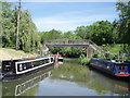
Saltford marina
The exit for boats from Saltford Marina onto the river Avon. The bridge carries a footpath
Image: © Sharon Loxton
Taken: 3 Jun 2006
0.08 miles
9
The Glen, Saltford, near Bath
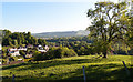
A private cul-de-sac of mainly large residential properties just off the A4 road. Picture taken from Saltford Golf Course.
Image: © Rick Crowley
Taken: 12 May 2020
0.08 miles
10
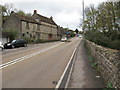
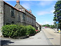
A4 Bath Road, Saltford
As the "Great Road" this was the main route from Bristol to London from the 17th century. By 1836 there were ten stage coaches to London each day. But with the coming of the railways, by 1843 the coach service had ceased. The road become important again from the early 1900s for motor traffic - then less important from 1971 when the M4 motorway became available through from Bristol to London.
Image: © David Hawgood
Taken: 15 Nov 2015
0.09 miles