IMAGES TAKEN NEAR TO
Uplands Road, BRISTOL, BS31 3JJ
Introduction
This page details the photographs taken nearby to Uplands Road, BS31 3JJ by members of the Geograph project.
The Geograph project started in 2005 with the aim of publishing, organising and preserving representative images for every square kilometre of Great Britain, Ireland and the Isle of Man.

There are currently over 7.5m images from over14,400 individuals and you can help contribute to the project by visiting https://www.geograph.org.uk
Image Map
Images are licensed for reuse under creativecommons.org/licenses/by-sa/2.0
Notes
- Clicking on the map will re-center to the selected point.
- The higher the marker number, the further away the image location is from the centre of the postcode.
Image Listing (102 Images Found)
Images are licensed for reuse under creativecommons.org/licenses/by-sa/2.0
Image
Details
Distance
1
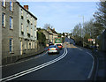
2010 : A4 entering Saltford on Bath Road
At the foot of Saltford Hill heading north west.
Image: © Maurice Pullin
Taken: 5 Feb 2010
0.10 miles
2
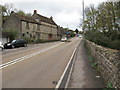
A4 Bath Road, Saltford
As the "Great Road" this was the main route from Bristol to London from the 17th century. By 1836 there were ten stage coaches to London each day. But with the coming of the railways, by 1843 the coach service had ceased. The road become important again from the early 1900s for motor traffic - then less important from 1971 when the M4 motorway became available through from Bristol to London.
Image: © David Hawgood
Taken: 15 Nov 2015
0.11 miles
4
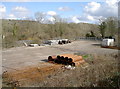
Ramshackle storage area
This flat area of ground is now used for storage of various materials, but once was the old Saltford railway station. The latter opened in 1840 but closed in 1970.
Image: © Neil Owen
Taken: 7 Mar 2018
0.12 miles
5
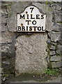
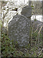
Seventh milestone and benchmark
Located at the top of the hill on the east side of Saltford, the stone also bears a 1GL benchmark.
See Image] for a wider view, http://www.deformedweb.co.uk/trigs/data/1GL/1GLA_049.png for the abstract of 1848-9, and http://www.bench-marks.org.uk/bm37081 for the Benchmark Database.
Image: © Neil Owen
Taken: 18 Feb 2011
0.12 miles
6
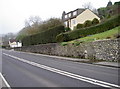
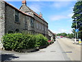
A4 Bath Road, Saltford
Putting the seventh milestone in context as the main Bristol to Bath road leaves Saltford. With such a large quantity of earth piled up against the stone wall, it is a small wonder that it has remained steadfast against the forces of nature.
It also bears a 1GL benchmark - see http://www.bench-marks.org.uk/bm37081 for the Benchmark Database and Image] for a detailed view.
Image: © Neil Owen
Taken: 18 Feb 2011
0.12 miles
7
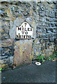
Old Milestone by the A4, Bath Road, Saltford
Metal plate attached to stone post by the A4, in parish of SALTFORD (BATH AND NORTH EAST SOMERSET District), Bath Road, near top of hill going into Saltford from Bath, embedded in stone retaining wall beside pavement, on West side of road. Bristol iron plate, erected by the Bristol turnpike trust in the 19th century.
Inscription reads:- : 7 / MILES / TO / BRISTOL :
Serifs. Carved benchmark at base of stone.
Milestone Society National ID: SO_BABR05.
Image: © JR Dowding
Taken: 19 Mar 2006
0.12 miles
8
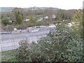
Railway yard, former Saltford station
The station closed in 1971. With increased population and increased use of railways, local people are lobbying to have the station reinstated. View from Bath Road.
Image: © David Hawgood
Taken: 15 Nov 2015
0.13 miles
9
Initialed stone
An odd piece of stonework just from the junction with the Bath Road, marking what appears to be the entrance to a garage. There is another, similar opposite - see Image] for a look and Image] for a wider view. Local boundaries do not appear to run through here so the supposition is that they are property markers. The initials appear to be 'P.P.'
Image: © Neil Owen
Taken: 7 Mar 2018
0.14 miles
10
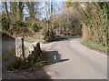
The start of The Shallows
The road off the A4 Bath Road swings sharply then turns again to go under the main railway line. As it does so, there are a small group of garages or stores. Marking the entrance are two initialed stones - see Image] for the one in shot here.
Image: © Neil Owen
Taken: 7 Mar 2018
0.14 miles