IMAGES TAKEN NEAR TO
The Batch, BRISTOL, BS31 3EN
Introduction
This page details the photographs taken nearby to The Batch, BS31 3EN by members of the Geograph project.
The Geograph project started in 2005 with the aim of publishing, organising and preserving representative images for every square kilometre of Great Britain, Ireland and the Isle of Man.

There are currently over 7.5m images from over14,400 individuals and you can help contribute to the project by visiting https://www.geograph.org.uk
Image Map
Images are licensed for reuse under creativecommons.org/licenses/by-sa/2.0
Notes
- Clicking on the map will re-center to the selected point.
- The higher the marker number, the further away the image location is from the centre of the postcode.
Image Listing (125 Images Found)
Images are licensed for reuse under creativecommons.org/licenses/by-sa/2.0
Image
Details
Distance
2
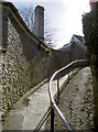
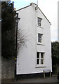
Down from The Batch
A short but steep path from The Batch to The Shallows is divided by a handrail.
Image: © Neil Owen
Taken: 7 Mar 2018
0.04 miles
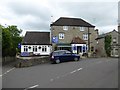
3
Bird in Hand, Saltford
A view of the pub and surrounding buildings from the bridge carrying the Bristol & Bath cycling route across Mead Lane.
Image: © Derek Harper
Taken: 9 Mar 2010
0.05 miles
5
Collins Buildings
In about 1904 this was once a shop in the High Street, and was called “Coombes” The bottom window was then a small square bay window, and the entrance was on the far side.
Image: © Rick Crowley
Taken: 6 Mar 2010
0.06 miles
6
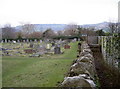
Footpath through the stones
The path leads beside the church of St Mary's, then cuts across the graveyard and out along the fields between the railway lines - one of which is now a cyclepath. A small sign indicates that the path has been diverted from its original course Image]
Image: © Neil Owen
Taken: 29 Jan 2011
0.06 miles
7
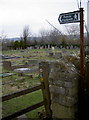
Footpath through the land of the departed
The path runs alongside St Mary's church, Saltford, and then is signed across the burial grounds via a stile. A nearby sign indicates that the path used to follow a different course. See Image]
Image: © Neil Owen
Taken: 29 Jan 2011
0.06 miles
8
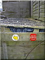
It used to go straight on?
A small but official bit of rural furniture tells observant travellers that the way ahead is no longer permitted. The asbestos-looking roofing and panel fencing adds credence.
Image: © Neil Owen
Taken: 29 Jan 2011
0.06 miles
9
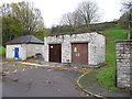
Pumping station and public toilets, The Shallows, Saltford
The Wessex Water pumping station is part of a major scheme taking sewage from Bath and district to the sewage works at Saltford - see Image] . Formerly some outflow in Bath went straight into the Avon as the sewage system was overloaded.
Image: © David Hawgood
Taken: 15 Nov 2015
0.06 miles
10
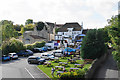
The Bird in Hand, Saltford
The back of the pub where there is a large beer garden. This is the view from the old railway bridge.
Image: © Bill Boaden
Taken: 28 Sep 2017
0.06 miles