IMAGES TAKEN NEAR TO
The Shallows, BRISTOL, BS31 3DA
Introduction
This page details the photographs taken nearby to The Shallows, BS31 3DA by members of the Geograph project.
The Geograph project started in 2005 with the aim of publishing, organising and preserving representative images for every square kilometre of Great Britain, Ireland and the Isle of Man.

There are currently over 7.5m images from over14,400 individuals and you can help contribute to the project by visiting https://www.geograph.org.uk
Image Map
Images are licensed for reuse under creativecommons.org/licenses/by-sa/2.0
Notes
- Clicking on the map will re-center to the selected point.
- The higher the marker number, the further away the image location is from the centre of the postcode.
Image Listing (117 Images Found)
Images are licensed for reuse under creativecommons.org/licenses/by-sa/2.0
Image
Details
Distance
1
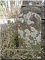
Initialed stone by the garage
An odd stone close to the small group of garages in Saltford, bearing what looks like the initials 'J.B.' It stands on the entrance opposite a similar stone with different initials - see Image] for the latter and Image] for a wider view.
Image: © Neil Owen
Taken: 7 Mar 2018
0.02 miles
2
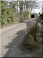
Hairpin into The Shallows
The turn into The Shallows off the A4 is a really tight one coming from Keynsham. The road leads under the railway line and in so doing passes this little row of garages, where a marker stone marks the entrance - see Image] for a closer look.
Image: © Neil Owen
Taken: 7 Mar 2018
0.02 miles
3
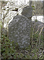
Initialed stone
An odd piece of stonework just from the junction with the Bath Road, marking what appears to be the entrance to a garage. There is another, similar opposite - see Image] for a look and Image] for a wider view. Local boundaries do not appear to run through here so the supposition is that they are property markers. The initials appear to be 'P.P.'
Image: © Neil Owen
Taken: 7 Mar 2018
0.03 miles
4
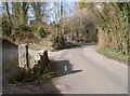
The start of The Shallows
The road off the A4 Bath Road swings sharply then turns again to go under the main railway line. As it does so, there are a small group of garages or stores. Marking the entrance are two initialed stones - see Image] for the one in shot here.
Image: © Neil Owen
Taken: 7 Mar 2018
0.03 miles
5
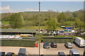
Railway embankment, Saltford
Close beside the river Avon, this embankment appears to have suffered land slip in the recent past, as it has acquired steel pilings.
Image: © Dr Duncan Pepper
Taken: 21 Sep 2008
0.04 miles
7
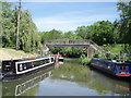
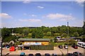
Saltford marina
The exit for boats from Saltford Marina onto the river Avon. The bridge carries a footpath
Image: © Sharon Loxton
Taken: 3 Jun 2006
0.06 miles
8
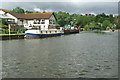
River Avon, above Kelston Lock
The fairly recent Riverside Inn at Saltford, overlooking Kelston lock and weir.
Image: © Pierre Terre
Taken: 20 May 2006
0.07 miles