IMAGES TAKEN NEAR TO
Stratton Road, BRISTOL, BS31 3BP
Introduction
This page details the photographs taken nearby to Stratton Road, BS31 3BP by members of the Geograph project.
The Geograph project started in 2005 with the aim of publishing, organising and preserving representative images for every square kilometre of Great Britain, Ireland and the Isle of Man.

There are currently over 7.5m images from over14,400 individuals and you can help contribute to the project by visiting https://www.geograph.org.uk
Image Map
Images are licensed for reuse under creativecommons.org/licenses/by-sa/2.0
Notes
- Clicking on the map will re-center to the selected point.
- The higher the marker number, the further away the image location is from the centre of the postcode.
Image Listing (12 Images Found)
Images are licensed for reuse under creativecommons.org/licenses/by-sa/2.0
Image
Details
Distance
1

Saltford Hall
Saltford Hall was paid for by donations from the inhabitants of Saltford and 'is administered by the Saltford Community Association (SCA), which is a registered charity, who aims to serve the needs of the local community as a first priority, although hirers from a wide area, including many nation-wide organisations, favour the site' https://www.saltfordhall.co.uk/about.html
On this Saturday afternoon it is being used as a venue to rehearse the choir for a forthcoming performance of Mahler's 8th Symphony.
Image: © HelenK
Taken: 4 Jul 2015
0.10 miles
2
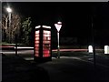
Saltford: red telephone box
It is close to 1am on a Monday morning as we look out of Norman Road onto the main A4 through the village. The red telephone box still contains a telephone and is well lit.
Image: © Chris Downer
Taken: 20 Feb 2017
0.17 miles
3
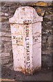
Old Boundary Marker by the A4, Bath Road, Saltford
Parish Boundary Marker - Turnpike by the A4, in parish of Saltford (Bath and North East Somerset District), outside No. 410 Bath Road, Saltford, opposite junction with Norman Road, on pavement against stone wall.
Inscription reads:-
: SALTFᴰ./ Pᴴ. : : 1823 / (BRI)STOL TURNPIKE TRUST : : KEYNSᴹ./ Pᴴ. :
Grade II listed.
List Entry Number: 1384655 https://historicengland.org.uk/listing/the-list/list-entry/1384655
Surveyed
Milestone Society National ID: SO_BABR08pb
Image: © A G Sutton
Taken: 3 Oct 2002
0.17 miles
4
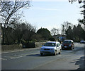
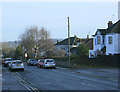
2010 : A4 entering Saltford from the north west
Keynsham is just over a mile behind.
After Saltford, Newton St. Loe then Bath.
Here we are well on our way through the Avon valley which it follows most of the way between Bristol and Bath, apart from a small divergence through Brislington.
Image: © Maurice Pullin
Taken: 5 Feb 2010
0.17 miles
5
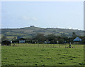
2010 : East from the A4 near Saltford
North west of the village.
Houses on the northern edge of Saltford can be seen and in the distance, although it's trees are bare of leaves, Kelston Round Hill Image still dominates.
Image: © Maurice Pullin
Taken: 5 Feb 2010
0.20 miles
6
2010 : Beech Road, Saltford
Heading north from the A4.
Image: © Maurice Pullin
Taken: 5 Feb 2010
0.22 miles
8
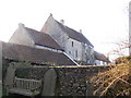
Saltford Manor House
Taken from the Church yard. An English manor house built in the 12th century is reputed to be the oldest continuously occupied home in Britain.
Saltford Manor House in Saltford, Somerset, boasts a Norman window in the main bedroom and 13th century ecclesiastical paintings in the spare room.
Image: © Rick Crowley
Taken: 24 Jan 2008
0.23 miles
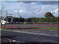
9
Saltford Library
A good place to get books and rent DVDs.
Image: © Class DE
Taken: 8 Nov 2006
0.23 miles
10

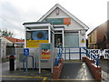
Saltford's vet
This can be found on the A4.
Image: © Class DE
Taken: 8 Nov 2006
0.23 miles