IMAGES TAKEN NEAR TO
Avon Close, BRISTOL, BS31 2UL
Introduction
This page details the photographs taken nearby to Avon Close, BS31 2UL by members of the Geograph project.
The Geograph project started in 2005 with the aim of publishing, organising and preserving representative images for every square kilometre of Great Britain, Ireland and the Isle of Man.

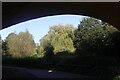
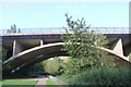
There are currently over 7.5m images from over14,400 individuals and you can help contribute to the project by visiting https://www.geograph.org.uk
Image Map
Images are licensed for reuse under creativecommons.org/licenses/by-sa/2.0
Notes
- Clicking on the map will re-center to the selected point.
- The higher the marker number, the further away the image location is from the centre of the postcode.
Image Listing (192 Images Found)
Images are licensed for reuse under creativecommons.org/licenses/by-sa/2.0
Image
Details
Distance
1
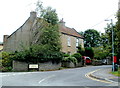
Northern end of Vandyck Avenue, Keynsham
Viewed from Avon Mill Lane. The large street name sign on the left shows that Vandyck Avenue leads to Avon Close, Tennyson Close and Constable Close.
Image: © Jaggery
Taken: 3 Sep 2011
0.04 miles
2
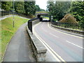
Avon Mill Lane approaches the A4 bridge, Keynsham
A view south towards the bridge carrying the Keynsham Bypass (the A4).
Image: © Jaggery
Taken: 3 Sep 2011
0.07 miles
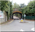
3
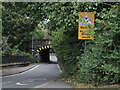
Avonmill Lane
The warning sign of a very narrow railway bridge (and a two-way traffic bottleneck) may not be readable these days.
Image: © Neil Owen
Taken: 10 Sep 2022
0.07 miles
4
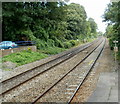
A view SE from Keynsham railway station
The line head towards Bath Spa station. Some trains stop at the intermediate station Oldfield Park.
A corner of the station car park http://www.geograph.org.uk/photo/3175449 is on the left.
Image: © Jaggery
Taken: 3 Sep 2011
0.08 miles
5
View of a willow tree through the arch of the Keynsham Bypass Bridge from Keynsham Memorial Park
Looking north-northeast.
Image: © Robert Lamb
Taken: 15 Sep 2023
0.09 miles
6
Low bridge ahead, Avon Mill Lane, Keynsham
Vegetation obscures a triangular sign on a railway bridge.
The sign shows that the height limit under the bridge is 9' 6" (2.9m).
Image: © Jaggery
Taken: 3 Sep 2011
0.09 miles
7
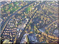
Aerial view of Keynsham
A weir on the River Avon, with the A4 and the Bath-Bristol railway, heading for Bristol.
Image: © M J Richardson
Taken: 23 Dec 2015
0.09 miles
8
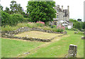
Keynsham Abbey (Remains)
Built about 1166 this was an Augustine Abbey set in a beautiful location near the river Chew and Avon. It was dissolved by Henry VIII in 1535. Apparently if Keynsham did not also have a Parish Church, it may have been spared. The Keynsham by-pass goes straight through the rest of the remains (A4).These remains are in the park and are fenced off from the public. The picture was taken during a special visit.
Image: © Rick Crowley
Taken: 18 Jun 2008
0.09 miles
9
View of the Keynsham Bypass bridge from Keynsham Memorial Park
Looking north-northeast.
Image: © Robert Lamb
Taken: 15 Sep 2023
0.09 miles
10
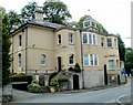
Grade II listed Avon House, Keynsham
Viewed across Avon Mill Lane. Now in use as offices, built as a house in the late 18th century,
with early 19th century additions. Grade II listed in December 1974.
An inscription on the wall shows that the building was renovated in 1985 by Ausnere Properties Ltd.
Image: © Jaggery
Taken: 3 Sep 2011
0.10 miles