IMAGES TAKEN NEAR TO
Chewton Keynsham, Keynsham, BRISTOL, BS31 2ST
Introduction
This page details the photographs taken nearby to BS31 2ST by members of the Geograph project.
The Geograph project started in 2005 with the aim of publishing, organising and preserving representative images for every square kilometre of Great Britain, Ireland and the Isle of Man.

There are currently over 7.5m images from over14,400 individuals and you can help contribute to the project by visiting https://www.geograph.org.uk
Image Map
Images are licensed for reuse under creativecommons.org/licenses/by-sa/2.0
Notes
- Clicking on the map will re-center to the selected point.
- The higher the marker number, the further away the image location is from the centre of the postcode.
Image Listing (5 Images Found)
Images are licensed for reuse under creativecommons.org/licenses/by-sa/2.0
Image
Details
Distance
1
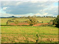
2008 : At the top of Fairy Hill near Compton Dando
Looking east.
Confession: did not see Kelston Round Hill Image in the background until it was downloaded.
Image: © Maurice Pullin
Taken: 16 Oct 2008
0.13 miles
2
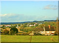
2008 : North from Fairy Hill
Looking toward Chewton Keynsham and Keynsham.
Image: © Maurice Pullin
Taken: 16 Oct 2008
0.16 miles
3
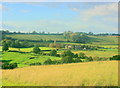
2008 : West near Burnett
Looking across the Chew Valley to Elm Park Farm.
Image: © Maurice Pullin
Taken: 16 Oct 2008
0.17 miles
4
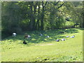
Herding in the shade
Some cows are enjoying the particularly warm and sunny April weather, perhaps too warm.
Image: © Neil Owen
Taken: 20 Apr 2020
0.23 miles
5
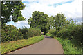
Chewton Road
Looking towards Chewton Keynsham.
Image: © Wayland Smith
Taken: 22 Aug 2020
0.23 miles