IMAGES TAKEN NEAR TO
Downfield, Staple Grove, BRISTOL, BS31 2HD
Introduction
This page details the photographs taken nearby to Downfield, Staple Grove, BS31 2HD by members of the Geograph project.
The Geograph project started in 2005 with the aim of publishing, organising and preserving representative images for every square kilometre of Great Britain, Ireland and the Isle of Man.

There are currently over 7.5m images from over14,400 individuals and you can help contribute to the project by visiting https://www.geograph.org.uk
Image Map
Images are licensed for reuse under creativecommons.org/licenses/by-sa/2.0
Notes
- Clicking on the map will re-center to the selected point.
- The higher the marker number, the further away the image location is from the centre of the postcode.
Image Listing (6 Images Found)
Images are licensed for reuse under creativecommons.org/licenses/by-sa/2.0
Image
Details
Distance
1
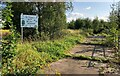
St Keyna's Wild Willow Wilderness
Wildlife area near Keynsham's primary school
Image: © Eirian Evans
Taken: 23 Aug 2021
0.17 miles
2
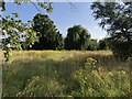
St Keyna's Wild Willow Wilderness
A haven for wildlife near Keynsham's primary school
Image: © Eirian Evans
Taken: 23 Aug 2021
0.17 miles
4
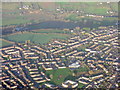
West Keynsham from the air
Looking north, about 14km from touchdown at Bristol airport. The unusually shaped building just above and to the right of the football field is St Keyna Primary School on Monmouth Road.
Image: © M J Richardson
Taken: 23 Dec 2015
0.18 miles
5
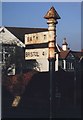
Old Direction Sign - Signpost by Charlton Road, Keynsham
Pyramid finial - 2 arms; Somerset SCC pyramid by the UC road, in parish of Keynsham (Bath and North East Somerset District), Charlton Road junction with St Ladoc Road.
Bath and North East Somerset HER listed.
HER number: 62314 https://www.heritagegateway.org.uk/Gateway/Results_Single.aspx?uid=62314&resourceID=1036
Surveyed
Milestone Society National ID: SO_ST6468A
Image: © Milestone Society
Taken: 1 Mar 2013
0.20 miles