IMAGES TAKEN NEAR TO
St. Ladoc Road, BRISTOL, BS31 2EQ
Introduction
This page details the photographs taken nearby to St. Ladoc Road, BS31 2EQ by members of the Geograph project.
The Geograph project started in 2005 with the aim of publishing, organising and preserving representative images for every square kilometre of Great Britain, Ireland and the Isle of Man.

There are currently over 7.5m images from over14,400 individuals and you can help contribute to the project by visiting https://www.geograph.org.uk
Image Map
Images are licensed for reuse under creativecommons.org/licenses/by-sa/2.0
Notes
- Clicking on the map will re-center to the selected point.
- The higher the marker number, the further away the image location is from the centre of the postcode.
Image Listing (40 Images Found)
Images are licensed for reuse under creativecommons.org/licenses/by-sa/2.0
Image
Details
Distance
1
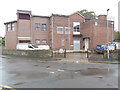
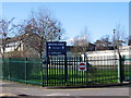
Keynsham Telephone Exchange
Situated in Culvers Road, this TE rather resembles a block of flats and has the code SSKEY. It serves 6,879 residential and 480 non-residential premises in Keynsham and Queen Charlton nearby. BT Openreach vehicles can be seen parked in front of this TE. It has the numbering range (0117) 986xxxx, the (0117) referring to the nineteen TEs in the Bristol group, and its postcode is BS31 2DW.
Image: © David Hillas
Taken: 21 Sep 2017
0.12 miles
2
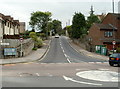
St Ladoc Road, Keynsham
Viewed from near a Bristol Road mini-roundabout.
An old-style sign and a new-style sign show 2¼ miles to Queen Charlton.
Image: © Jaggery
Taken: 3 Sep 2011
0.14 miles
3
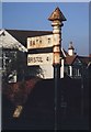
Old Direction Sign - Signpost by Charlton Road, Keynsham
Pyramid finial - 2 arms; Somerset SCC pyramid by the UC road, in parish of Keynsham (Bath and North East Somerset District), Charlton Road junction with St Ladoc Road.
Bath and North East Somerset HER listed.
HER number: 62314 https://www.heritagegateway.org.uk/Gateway/Results_Single.aspx?uid=62314&resourceID=1036
Surveyed
Milestone Society National ID: SO_ST6468A
Image: © Milestone Society
Taken: 1 Mar 2013
0.15 miles
4
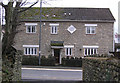
Milward Lodge 1600
This substantial house was built in what was the original core of Keynsham.
Image: © Rick Crowley
Taken: 28 Feb 2010
0.16 miles
5
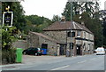
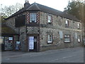
Crown Inn, Keynsham
Pub with accommodation available, located at 63 Bristol Road.
Image: © Jaggery
Taken: 3 Sep 2011
0.16 miles
6
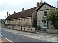
Grade II listed Bridges Almshouses, Keynsham
Located at 46-56 Bristol Road (A4175). A terrace of six almshouses built in 1685, founded by Sir Thomas Bridges. There are two armorial cartouches at the level of the upper-floor windows. A lion represents Lady Anna Rodney, and a cross, Sir Thomas Bridges.
My own mundane observation was how small the black front doors are - about 5 feet high, at most.
The almshouses were Grade II listed in February 1950.
On the right at 44 Bristol Road is Virginia House.
Image: © Jaggery
Taken: 3 Sep 2011
0.16 miles
7
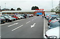
Tesco Keynsham
Tesco Keynsham opened in 2010 on a brownfield site, a former car park adjacent to St John's Court.
Image: © Jaggery
Taken: 3 Sep 2011
0.16 miles
8
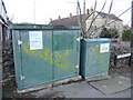
Combined sewer overflow units
Keynsham is close to the Rivers Chew and Avon, which are noted for flooding at times. Several water management utility boxes are stationed around the town.
Image: © Neil Owen
Taken: 17 Jan 2023
0.17 miles
10
Recognising the work of the NHS
The Crown in Keynsham sports a poster to laud the staff of the NHS in this hour of Covid-19 crisis. The same poster then advertises a home delivery service (with a typo).
Image: © Neil Owen
Taken: 11 Apr 2020
0.17 miles