IMAGES TAKEN NEAR TO
Pool Barton, BRISTOL, BS31 2EP
Introduction
This page details the photographs taken nearby to Pool Barton, BS31 2EP by members of the Geograph project.
The Geograph project started in 2005 with the aim of publishing, organising and preserving representative images for every square kilometre of Great Britain, Ireland and the Isle of Man.

There are currently over 7.5m images from over14,400 individuals and you can help contribute to the project by visiting https://www.geograph.org.uk
Image Map
Images are licensed for reuse under creativecommons.org/licenses/by-sa/2.0
Notes
- Clicking on the map will re-center to the selected point.
- The higher the marker number, the further away the image location is from the centre of the postcode.
Image Listing (147 Images Found)
Images are licensed for reuse under creativecommons.org/licenses/by-sa/2.0
Image
Details
Distance
1
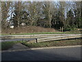
Is it an official crossing?
In the past the footpath used to run across the field here but the Keynsham Bypass was built in the 1960s, cutting through it. Has there been a tacit ackowledgement that the path still crosses the dual carriageway? The short concrete path in the central reservation appears to carry on to the other side, where it meets up with other paths. See Image] for more evidence.
Image: © Neil Owen
Taken: 17 Jan 2023
0.03 miles
2
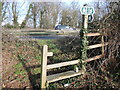
A path of peril?
The public footpaths around the west end of Keynsham are bisected by the bypass. It appears that the stile marks where historic paths crossed the fields before construction. See Image] for a look further over the road.
Image: © Neil Owen
Taken: 17 Jan 2023
0.04 miles
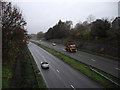
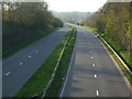
4
2010 : A4 Keynsham Bypass
Seen from a footpath through a gap in the hedgerow.
The main rail line between Bristol and Bath is on the next embankment over.
The River Avon is on the other side of the field, where the bushes and trees begin.
Image: © Maurice Pullin
Taken: 6 Sep 2010
0.05 miles
5
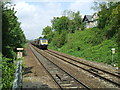
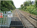
Keynsham Railway Station, Bristol.
A view of the cutting to the West of Keynsham Railway Station, Bristol.
Image: © Shaun O'Sullivan
Taken: 17 May 2013
0.06 miles
6
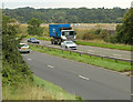
Giving the bypass a miss
The Keynsham bypass is almost empty today as the Covid-19 lockdown takes people off the roads.
Image: © Neil Owen
Taken: 11 Apr 2020
0.06 miles
7
2010 : A4175 Bristol Road, Keynsham
Formerly the A4 which now occupies the Keynsham bypass. The A4175 ends (or begins) at the roundabout at the western end of the bypass.
Image: © Maurice Pullin
Taken: 15 Mar 2010
0.06 miles
8
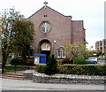
St Dunstans, Keynsham
The Catholic Parish Church of St Dunstan, Keynsham, is on the north side of Bristol Road.
The foundation stone was laid on March 16th 1935. The first Mass was celebrated on October 20th of the same year. The church is dedicated to St Dunstan (909–988), Abbot of Glastonbury Abbey, later (960–978) Archbishop of Canterbury.
Image: © Jaggery
Taken: 3 Sep 2011
0.07 miles
9
A view NW from Keynsham railway station
Looking in the direction of Bristol Temple Meads station. The houses are in The Avenue. http://www.geograph.org.uk/photo/3175341
Image: © Jaggery
Taken: 3 Sep 2011
0.07 miles
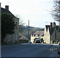
10
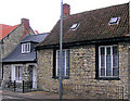
Old Building, Station Rd, Keynsham
This building apparently dates back to 1343, and in the vicinity of the Abbey at that time. It has what is perhaps some memorabilia of the abbey in its wall see http://www.geograph.org.uk/photo/1730350.
Image: © Rick Crowley
Taken: 28 Feb 2010
0.07 miles