IMAGES TAKEN NEAR TO
St. Francis Road, BRISTOL, BS31 2EA
Introduction
This page details the photographs taken nearby to St. Francis Road, BS31 2EA by members of the Geograph project.
The Geograph project started in 2005 with the aim of publishing, organising and preserving representative images for every square kilometre of Great Britain, Ireland and the Isle of Man.

There are currently over 7.5m images from over14,400 individuals and you can help contribute to the project by visiting https://www.geograph.org.uk
Image Map
Images are licensed for reuse under creativecommons.org/licenses/by-sa/2.0
Notes
- Clicking on the map will re-center to the selected point.
- The higher the marker number, the further away the image location is from the centre of the postcode.
Image Listing (19 Images Found)
Images are licensed for reuse under creativecommons.org/licenses/by-sa/2.0
Image
Details
Distance
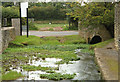
2
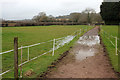
Footpath, Stockwood Vale
Footpath BA 27/7 is a little flooded on this stretch by the Stockwood Vale Stream. It then gets very very muddy.
Image: © Derek Harper
Taken: 10 Mar 2018
0.10 miles
3
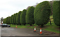
Trees by the car park, Brookleaze
On footpath BA 27/7.
Image: © Derek Harper
Taken: 10 Mar 2018
0.11 miles
4

Rather wet footpath, Stockwood Vale
At this point along the path (BA 27/7) shown in Image] I had to turn back, as my walking shoes, though sturdy, would have been completely submerged in this liquid mud almost at the start of my walk, and I hadn't brought my wellies on this trip to Bristol. There's a certain irony in the notice, although mud without dog poo in it is obviously preferable to mud with dog poo in it.
Image: © Derek Harper
Taken: 10 Mar 2018
0.14 miles
6
Site of Old Tanyard
This was site of Keynsham Tannery, which needed plenty of water.
Image: © Rick Crowley
Taken: 28 Feb 2010
0.16 miles
7
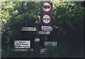
Old Direction Sign - Signpost by Stockwood Hill, Keynsham parish
Pyramid finial - 2 arms; Somerset SCC pyramid by the UC road, in parish of Keynsham (Bath And North East Somerset District), Stockwood Hill junction with Charlton Bottom, Stockwood Vale.
Surveyed
Milestone Society National ID: SO_ST6468B
Image: © Milestone Society
Taken: Unknown
0.19 miles
8
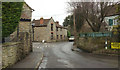
Brookleaze
A winter version, over 7 years on, of Image, with Stockwood Hill leading off the Old Bristol Road.
Image: © Derek Harper
Taken: 10 Mar 2018
0.19 miles
9
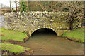
Bridge over Stockwood Vale Stream
The bridge carries a public footpath (BA 27/7), as the sign indicates. On the left is the Old Bristol Road. See also Image
Image: © Derek Harper
Taken: 10 Mar 2018
0.19 miles
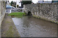
10
2010 : Site of old tanyard
Thought this was a ford until I saw Image This view is from the opposite direction.
Have taken my C1 through some strange places in pursuit of Geographs, but this would be too much.
The sign at the other end which said "Ford" was for a car showroom.
Image: © Maurice Pullin
Taken: 6 Sep 2010
0.20 miles