IMAGES TAKEN NEAR TO
Keynsham Road, BRISTOL, BS31 2DE
Introduction
This page details the photographs taken nearby to Keynsham Road, BS31 2DE by members of the Geograph project.
The Geograph project started in 2005 with the aim of publishing, organising and preserving representative images for every square kilometre of Great Britain, Ireland and the Isle of Man.

There are currently over 7.5m images from over14,400 individuals and you can help contribute to the project by visiting https://www.geograph.org.uk
Image Map
Images are licensed for reuse under creativecommons.org/licenses/by-sa/2.0
Notes
- Clicking on the map will re-center to the selected point.
- The higher the marker number, the further away the image location is from the centre of the postcode.
Image Listing (133 Images Found)
Images are licensed for reuse under creativecommons.org/licenses/by-sa/2.0
Image
Details
Distance
1
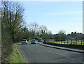
2010 : A4175 Approaching Keynsham
Having come from Willsbridge, here it crosses the Avon Valley.
Image: © Maurice Pullin
Taken: 15 Mar 2010
0.05 miles
2
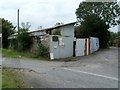
A Keynsham scrapyard
Located alongside Keynsham Road near Keynsham Lock http://www.geograph.org.uk/photo/3264282 on the Kennet and Avon Canal.
Notices on the premises show
"KEYNSHAM SCRAPYARD RECYCLING" and
"FULLY LICENCED TURN YOUR SCRAP CARS INTO CASH".
Image: © Jaggery
Taken: 3 Sep 2011
0.05 miles
3
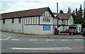
Premises for sale near Keynsham Lock
At the September 2011 date of this view, there was a For Sale sign outside the former premises of Matthews Roofing Ltd, who have moved to new premises in Tower Lane, Warmley, Bristol.
Image: © Jaggery
Taken: 3 Sep 2011
0.07 miles
4
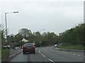
A4175 Keynsham Road
The southbound bus stop serving the nearby Marina may be seen to the left of the photograph.
Image: © Ruth Riddle
Taken: 4 May 2012
0.07 miles
5
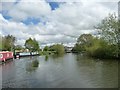
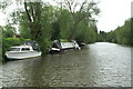
River Avon, near Broad Mead
Looking upstream, from a boat travelling downstream.
Image: © Christine Johnstone
Taken: 3 May 2015
0.10 miles
6
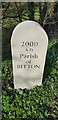
Not So Old Boundary Marker on the A4175 Keynsham Road
Commemorative Marker on the northwest side of the A4175 Keynsham Road
. BITTON parish. Inscribed 2000 / A. D. / Parish / of / BITTON. See also https://www.geograph.org.uk/photo/4807233
Milestone Society National ID: GL_BITT02cm
Image: © D Dickson
Taken: 11 Mar 2019
0.11 miles
7
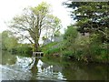
Riverside building and jetty, near Keynsham Hams
On the south bank of the River Avon. Possibly to do with drainage? The yellow triangle, in this context, must warn of a dangerous hazard.
Image: © Christine Johnstone
Taken: 4 May 2015
0.12 miles
8
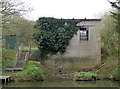
Forlorn on the foreshore
A disused utilitarian building on the banks of the River Avon, now being reclaimed by the greenery.
Image: © Neil Owen
Taken: 29 Mar 2017
0.12 miles
9
River Avon below Broad Mead
Looking downstream towards Keynsham
Image: © Pierre Terre
Taken: 20 May 2006
0.12 miles
10
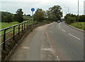
Road from Keynsham to Willsbridge
The A4175 here follows a route through the Avon valley on the east side of the river.
The blue sign shows that the pavement is for pedestrians and cyclists.
Image: © Jaggery
Taken: 3 Sep 2011
0.13 miles