IMAGES TAKEN NEAR TO
Tilley Close, BRISTOL, BS31 1XN
Introduction
This page details the photographs taken nearby to Tilley Close, BS31 1XN by members of the Geograph project.
The Geograph project started in 2005 with the aim of publishing, organising and preserving representative images for every square kilometre of Great Britain, Ireland and the Isle of Man.

There are currently over 7.5m images from over14,400 individuals and you can help contribute to the project by visiting https://www.geograph.org.uk
Image Map
Images are licensed for reuse under creativecommons.org/licenses/by-sa/2.0
Notes
- Clicking on the map will re-center to the selected point.
- The higher the marker number, the further away the image location is from the centre of the postcode.
Image Listing (9 Images Found)
Images are licensed for reuse under creativecommons.org/licenses/by-sa/2.0
Image
Details
Distance
1
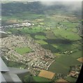
Keynsham from the air
A different aerial angle on the same estate on the southeast side of Keynsham is at Image Beyond the estate is the Ashmead Business Park.
Image: © Derek Harper
Taken: 8 Sep 2016
0.12 miles
2
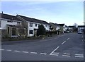
Cadbury Way, Keynsham
An estate on the southern fringe of the town.
Image: © Roger Cornfoot
Taken: 13 Mar 2007
0.12 miles
3
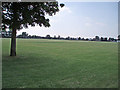
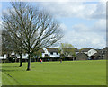
Playing Field
This large playing field is surrounded by housing estates in the south east area of Keynsham.
Image: © Sharon Loxton
Taken: 17 Jun 2006
0.15 miles
4
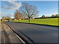
Manor Road Playing Field
This playing field https://sports-facilities.co.uk/sites/view/6001121 is 'protected by Fields in Trust in perpetuity' https://www.fieldsintrust.org/FieldSite/Manor-Road-Keynsham . It is equipped for football but today was being used mainly by dog walkers. Manor Road itself winds on, becoming increasingly narrow and muddy, until it emerges in Saltford.
Image: © HelenK
Taken: 17 Nov 2022
0.16 miles
5
2009 : Manor Road Playing Field, Keynsham
The houses on the far side of the playing field are a relatively new development on Lytes Cary Road.
Image: © Maurice Pullin
Taken: 7 Apr 2009
0.19 miles
6
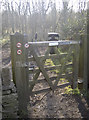
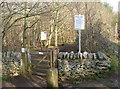
An entrance to Middle Tyning
This gate allows entry into the southern field that is now part of the Manor Road Community Woodland. Notices are arranged to prohibit dogs, horses and motorbikes. The woodland name comes from the 1841 maps of the area.
Image: © Neil Owen
Taken: 23 Feb 2018
0.21 miles
7
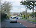
2009 : B3116 approaching Keynsham
The valley of the River Chew is to the left. Longwell Green is in the distance straight ahead.
Image: © Maurice Pullin
Taken: 7 Apr 2009
0.22 miles
8
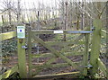
A gate for the gee-gees
Very close to the gate that prohibits horses is this gate - positively encouraging them. There must be all of about 10m between the two paths through the woods.
Image: © Neil Owen
Taken: 23 Feb 2018
0.22 miles
9
Entrance to Hurn from Manor Road
One of the entrances to the Community Woodland. Dogs are permitted here, but not horses or motorbikes.
Image: © Neil Owen
Taken: 23 Feb 2018
0.24 miles