IMAGES TAKEN NEAR TO
Waveney Road, BRISTOL, BS31 1RX
Introduction
This page details the photographs taken nearby to Waveney Road, BS31 1RX by members of the Geograph project.
The Geograph project started in 2005 with the aim of publishing, organising and preserving representative images for every square kilometre of Great Britain, Ireland and the Isle of Man.

There are currently over 7.5m images from over14,400 individuals and you can help contribute to the project by visiting https://www.geograph.org.uk
Image Map
Images are licensed for reuse under creativecommons.org/licenses/by-sa/2.0
Notes
- Clicking on the map will re-center to the selected point.
- The higher the marker number, the further away the image location is from the centre of the postcode.
Image Listing (11 Images Found)
Images are licensed for reuse under creativecommons.org/licenses/by-sa/2.0
Image
Details
Distance
1
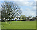
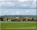
2009 : Manor Road Playing Field, Keynsham
The houses on the far side of the playing field are a relatively new development on Lytes Cary Road.
Image: © Maurice Pullin
Taken: 7 Apr 2009
0.07 miles
2
Manor Road Playing Field
This playing field https://sports-facilities.co.uk/sites/view/6001121 is 'protected by Fields in Trust in perpetuity' https://www.fieldsintrust.org/FieldSite/Manor-Road-Keynsham . It is equipped for football but today was being used mainly by dog walkers. Manor Road itself winds on, becoming increasingly narrow and muddy, until it emerges in Saltford.
Image: © HelenK
Taken: 17 Nov 2022
0.09 miles
3
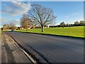
2009 : Medway Drive, Keynsham
Opposite the playing field on Manor Road.
Image: © Maurice Pullin
Taken: 7 Apr 2009
0.10 miles
4
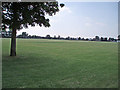
Playing Field
This large playing field is surrounded by housing estates in the south east area of Keynsham.
Image: © Sharon Loxton
Taken: 17 Jun 2006
0.14 miles
5
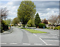
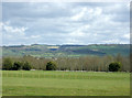
2009 : East of Keynsham from Manor Road
Turning north now from Manor Road the scene is now a little more industrial, though most of the industry formerly associated with Keynsham is now at an end.
Image: © Maurice Pullin
Taken: 7 Apr 2009
0.18 miles
6
2009 : North east from Manor Road
Turning to the left from Image the view is now toward Upton Cheyney and Beach on the other side of the River Avon. Lansdown stands behind and to the right.
Image: © Maurice Pullin
Taken: 7 Apr 2009
0.23 miles
7
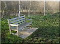
Nigel's seat
The Manor Road Community Woodlands were started in 1993 with the aim of planting more trees on the former farm fields. One of the main instigators and supporters of the Friends of Manor Road Community Woodlands was Nigel Jacks, who is commemorated here.
Image: © Neil Owen
Taken: 23 Feb 2018
0.23 miles
8
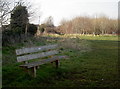
Birthday bench
A bench in the meadow commemorates the birthday of a local lady, who was born just up the Manor Road.
Image: © Neil Owen
Taken: 23 Feb 2018
0.24 miles
9
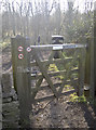
An entrance to Middle Tyning
This gate allows entry into the southern field that is now part of the Manor Road Community Woodland. Notices are arranged to prohibit dogs, horses and motorbikes. The woodland name comes from the 1841 maps of the area.
Image: © Neil Owen
Taken: 23 Feb 2018
0.24 miles
10
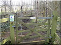
A gate for the gee-gees
Very close to the gate that prohibits horses is this gate - positively encouraging them. There must be all of about 10m between the two paths through the woods.
Image: © Neil Owen
Taken: 23 Feb 2018
0.24 miles