IMAGES TAKEN NEAR TO
Gaston Avenue, BRISTOL, BS31 1NB
Introduction
This page details the photographs taken nearby to Gaston Avenue, BS31 1NB by members of the Geograph project.
The Geograph project started in 2005 with the aim of publishing, organising and preserving representative images for every square kilometre of Great Britain, Ireland and the Isle of Man.

There are currently over 7.5m images from over14,400 individuals and you can help contribute to the project by visiting https://www.geograph.org.uk
Image Map
Images are licensed for reuse under creativecommons.org/licenses/by-sa/2.0
Notes
- Clicking on the map will re-center to the selected point.
- The higher the marker number, the further away the image location is from the centre of the postcode.
Image Listing (24 Images Found)
Images are licensed for reuse under creativecommons.org/licenses/by-sa/2.0
Image
Details
Distance
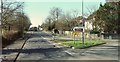
1
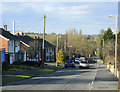
2010 : Unity Road, Keynsham
A residential road which was cut in two by the Keynsham bypass. On the other side of the bypass the road passes under the Bristol to Bath railway line. A sewage works beyond that, unseen and, one hopes unsmelt.
Image: © Maurice Pullin
Taken: 15 Mar 2010
0.04 miles
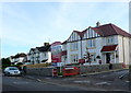
2

The Grange Hotel, Keynsham
A certain amount of disruption has not stopped the hotel from staying open. See Image] for a view of the works.
Image: © Neil Owen
Taken: 9 Feb 2012
0.07 miles
3

Work in progress
The plot of land beside the Grange Hotel, Keynsham, is now going to be something different to the bungalow that used to be here. See Image] for a view of the hotel.
Image: © Neil Owen
Taken: 9 Feb 2012
0.08 miles
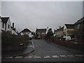
4
Newland at The Grange
These new houses must be a wonder of compactness as there are 14 new houses on a plot that used to have one bungalow. Perhaps they took some land from the rear of the hotel next door. Or maybe they have tiny gardens.
Image: © Nigel Mykura
Taken: 18 Nov 2012
0.08 miles
5
2010 : B3116 Bath Road, Keynsham
Formerly the A4 until the Keynsham Bypass was built.
Image: © Maurice Pullin
Taken: 15 Mar 2010
0.08 miles
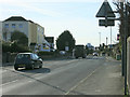
7
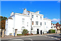
Bath Road
Impressive building on Bath Road, in Keynsham.
Image: © Wayland Smith
Taken: 10 Oct 2021
0.13 miles
8
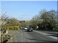
2010 : B3116 Bath Road, Keynsham
The B3116 nears one of its ends a few hundred yards ahead at the roundabout at the eastern end of the Keynsham bypass. The B3116 has three ends, one here, one in the middle of Keynsham and one, which you could call a beginning, further south on the A39 near Stantonbury Hill.
Kelston Round Hill Image appears on the skyline.
Image: © Maurice Pullin
Taken: 15 Mar 2010
0.14 miles
9
Bath Road, Keynsham
A reverse view of Image along the B3116 from the Broadmead roundabout at the eastern end of the Keynsham bypass.
Image: © Derek Harper
Taken: 24 Feb 2016
0.15 miles
10
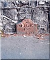
Old Milepost by the B3116, Bath Road, Keynsham Parish
Cast iron post by the B3116, in parish of KEYNSHAM (BATH AND NORTH EAST SOMERSET District), Bath Road, by Chandag Road Esso garage, low down in pavement in front of stone wall, on South side of road. Old Bristol iron plate, erected by the Bristol turnpike trust in the 18th century.
Inscription reads:- : 5 / MILES / TO / BRISTOL :
Milestone Society National ID: SO_BABR07.
Image: © JR Dowding
Taken: 21 Jul 2008
0.17 miles