IMAGES TAKEN NEAR TO
Temple Street, BRISTOL, BS31 1HD
Introduction
This page details the photographs taken nearby to Temple Street, BS31 1HD by members of the Geograph project.
The Geograph project started in 2005 with the aim of publishing, organising and preserving representative images for every square kilometre of Great Britain, Ireland and the Isle of Man.

There are currently over 7.5m images from over14,400 individuals and you can help contribute to the project by visiting https://www.geograph.org.uk
Image Map
Images are licensed for reuse under creativecommons.org/licenses/by-sa/2.0
Notes
- Clicking on the map will re-center to the selected point.
- The higher the marker number, the further away the image location is from the centre of the postcode.
Image Listing (156 Images Found)
Images are licensed for reuse under creativecommons.org/licenses/by-sa/2.0
Image
Details
Distance
1
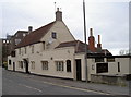
The Ship Inn, Keynsham
Built in 1750, this old inn is still thriving and is also home to a petanque club.
Image: © Neil Owen
Taken: 30 Jan 2018
0.02 miles
2
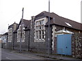
The former Temple Infants school
Keynsham has a number of schools, this one being a Victorian provision for infants. It finally closed and was converted into residential flats.
Image: © Neil Owen
Taken: 30 Jan 2018
0.02 miles
4
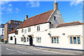
Keynsham, The Ship Inn
Pub with traditional layout on Temple Street; two rooms, bar at back, TV, darts, beer garden. Cask ales on offer at my visit: Brakspear Oxford Gold, Marston Bitter, Pedigree, Ringwood Best, Fortyniner, Wychwood Cherry Picker. For some customer comments, see http://www.beerintheevening.com/pubs/s/24/24489/Ship_Inn/Keynsham
Image: © Mike Faherty
Taken: 21 Jul 2011
0.03 miles
5
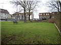
Prayers - a thing of the past
This grassy patch at the junction of Dapps Hill, Albert Road and Temple Street lies peaceful enough but it was the site of a chapel. Originally a Primitive Methodist chapel, it later became the Elim Pentecostal before the congregation moved elsewhere. The small chapel was demolished, not to be replaced.
Image: © Neil Owen
Taken: 30 Jan 2018
0.04 miles
6
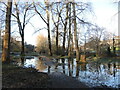
The Chew reaches out
In times of prolonged rain the park alongside the River Chew will flood too. It has been worse.
Image: © Neil Owen
Taken: 17 Jan 2023
0.04 miles
7
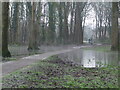
A flooded path
The users in Memorial Park are given a bit of a tricky decision. A short section of the path is submerged enough to dampen the laces.
Image: © Neil Owen
Taken: 1 Jan 2021
0.04 miles
8
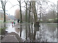
The irresistible urge to splash
Having negotiated the slight flooding, it seems children cannot miss the chance to go deeper.
Image: © Neil Owen
Taken: 1 Jan 2021
0.04 miles
9
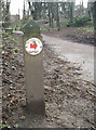
Dapps Hill for the runners
A marker post points runners in the right direction. Run England was rebranded as Run Together in 2015.
Image: © Neil Owen
Taken: 30 Jan 2018
0.04 miles
10
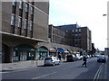
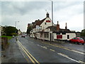
District Council offices, Keynsham
The Bath and North East Somerset 'Riverside' building, in Temple Street.
Image: © Roger Cornfoot
Taken: 13 Mar 2007
0.05 miles