IMAGES TAKEN NEAR TO
Dapps Hill, BRISTOL, BS31 1EU
Introduction
This page details the photographs taken nearby to Dapps Hill, BS31 1EU by members of the Geograph project.
The Geograph project started in 2005 with the aim of publishing, organising and preserving representative images for every square kilometre of Great Britain, Ireland and the Isle of Man.

There are currently over 7.5m images from over14,400 individuals and you can help contribute to the project by visiting https://www.geograph.org.uk
Image Map
Images are licensed for reuse under creativecommons.org/licenses/by-sa/2.0
Notes
- Clicking on the map will re-center to the selected point.
- The higher the marker number, the further away the image location is from the centre of the postcode.
Image Listing (108 Images Found)
Images are licensed for reuse under creativecommons.org/licenses/by-sa/2.0
Image
Details
Distance
1
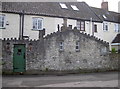
A particular architecture
Some cottages at the bottom of Dapps Hill feature plenty of individual details. See Image] for one of them.
Image: © Neil Owen
Taken: 30 Jan 2018
0.00 miles
2

A burnished figure
One of the two such figures that stand guard beside the doorway of some cottages at the bottom of Dapps Hill. There are many more little details - see Image
Image: © Neil Owen
Taken: 30 Jan 2018
0.00 miles
3
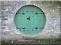
Round entrance
Along with a number of intriguing features, this circular 'doorway' is part of some interesting cottages at the bottom of Dapps Hill. See Image
Image: © Neil Owen
Taken: 30 Jan 2018
0.01 miles
4
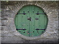
So that's where they live
A round wooden opening in the wall now sports a little sign, reading 'Beware of the Hobbitt'. Compare the same shot of 2018, Image
Image: © Neil Owen
Taken: 11 Sep 2022
0.01 miles
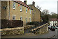
5
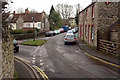
Junction on the Two Rivers Way
Dapps Hill drops to a grass triangle at the junction with Gooseberry lane (left, crossing the River Chew) and St Clements Road (ahead). On the left are the listed Chew Cottages https://www.historicengland.org.uk/listing/the-list/list-entry/1384609 : "the cottages were rented by the parish as poor houses in the early C19".
Image: © Derek Harper
Taken: 10 Mar 2018
0.02 miles
6
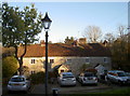
Chew Cottages
The date stone reads 1824. The lamppost is probably a little after that.
Image: © Neil Owen
Taken: 30 Nov 2017
0.02 miles
7
Dapps Hill bridge over the Chew
This little bridge dates from the late seventeenth century, being 'Coursed rubble and some dressed stone to buttresses and arches; two segmental arches with centre buttress-cutwaters set diagonally.' In the floods of 1968, it was very badly damaged and needed considerable repairs. On this view the waters rose up to near the top of the angled roofline beyond the two people.
Image: © Neil Owen
Taken: 30 Jan 2018
0.02 miles
8
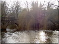
Dapps Hill bridge
Partly veiled by weeping branches, the bridge was largely rebuilt after the tremendous flooding of 1968.
Image: © Neil Owen
Taken: 30 Jan 2018
0.02 miles
9
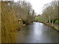
The Chew through the park
The River Chew wends its way through Keynsham, as seen here from Dapps Hill bridge.
Image: © Neil Owen
Taken: 30 Jan 2018
0.02 miles
10
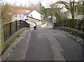
St Clements Road, Keynsham
Dropping down towards the junction shown from the other direction in
Image], with a pavement climbing high above the roadway.
Image: © Derek Harper
Taken: 10 Mar 2018
0.03 miles