IMAGES TAKEN NEAR TO
St. Clements Road, BRISTOL, BS31 1AB
Introduction
This page details the photographs taken nearby to St. Clements Road, BS31 1AB by members of the Geograph project.
The Geograph project started in 2005 with the aim of publishing, organising and preserving representative images for every square kilometre of Great Britain, Ireland and the Isle of Man.

There are currently over 7.5m images from over14,400 individuals and you can help contribute to the project by visiting https://www.geograph.org.uk
Image Map
Images are licensed for reuse under creativecommons.org/licenses/by-sa/2.0
Notes
- Clicking on the map will re-center to the selected point.
- The higher the marker number, the further away the image location is from the centre of the postcode.
Image Listing (23 Images Found)
Images are licensed for reuse under creativecommons.org/licenses/by-sa/2.0
Image
Details
Distance
1
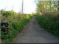
Old Lane out of Keynsham
The northern end of the 'green' lane that goes south from Keynsham to Chewton Place. It is an unsealed, unclassified road.
Image: © James Ayres
Taken: 27 Apr 2010
0.05 miles
2
Keynsham allotments
Gardeners have been growing here since the 1960s. An allotment association was formed in 1987 that works in conjunction with the local council to look after the land. This co-operation is the only one in the town.
Image: © Neil Owen
Taken: 30 Nov 2017
0.05 miles
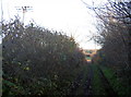
3
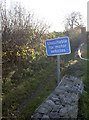
Parkhouse Lane
Maybe passable by two wheels or an ATV. This old lane goes on to Parkhouse Farm and on towards Queen Charlton.
Image: © Neil Owen
Taken: 30 Nov 2017
0.06 miles
4
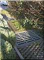
Grids and cobbles
Two sets of each at the start of Parkhouse Lane, with the understanding that the lane is not suitable for motor traffic.
Image: © Neil Owen
Taken: 30 Nov 2017
0.06 miles
5
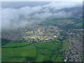
Keynsham from the air
Looking north along the River Chew from a Bristol bound flight from Glasgow which is about to enter clouds on the approach to Bristol.
Image: © Thomas Nugent
Taken: 16 Aug 2011
0.13 miles
6
The other lane by the allotments
Bounded by Parkhouse Lane on the west side, the allotments have this un-named lane on the east.
Image: © Neil Owen
Taken: 30 Nov 2017
0.15 miles
7
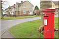
Coronation Avenue, Keynsham
At the junction with park Road. The Elizabeth II postbox is number BS31 400.
Image: © Derek Harper
Taken: 10 Mar 2018
0.16 miles
8
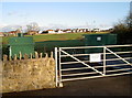
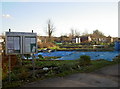
St Clements Road sewage pumping station
A small, inconspicuous but vitally important bit of urban equipment. Incidentally, St Clements Road is a change for what was known as Workhouse Lane before WWII. Indeed, the Union Workhouse was a short distance away but is now the site of a modern hospital.
Image: © Neil Owen
Taken: 30 Nov 2017
0.17 miles
9
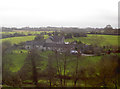
Conygre Farm
Viewed from the Wellsway and across the River Chew.
Image: © Neil Owen
Taken: 30 Jan 2018
0.17 miles
10
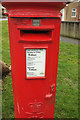
Postbox, Coronation Avenue, Keynsham
Elizabeth II postbox number BS31 400, at the corner of Park Road, is also shown in Image
Image: © Derek Harper
Taken: 10 Mar 2018
0.17 miles