IMAGES TAKEN NEAR TO
Long Beach Road, BRISTOL, BS30 9UA
Introduction
This page details the photographs taken nearby to Long Beach Road, BS30 9UA by members of the Geograph project.
The Geograph project started in 2005 with the aim of publishing, organising and preserving representative images for every square kilometre of Great Britain, Ireland and the Isle of Man.

There are currently over 7.5m images from over14,400 individuals and you can help contribute to the project by visiting https://www.geograph.org.uk
Image Map (Loading...)


Getting Data...Please wait
Leaflet Map data © OpenStreetMap
Images are licensed for reuse under creativecommons.org/licenses/by-sa/2.0
Notes
- Clicking on the map will re-center to the selected point.
- The higher the marker number, the further away the image location is from the centre of the postcode.
Image Listing (21 Images Found)
Images are licensed for reuse under creativecommons.org/licenses/by-sa/2.0
Image
Details
Distance
2
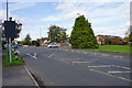
Bath Road at its junction with Long Beach Road
The side road gives access to fairly modern housing estates.
Image: © Bill Boaden
Taken: 28 Sep 2017
0.17 miles
3
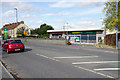
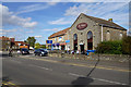
My Local
A supermarket which has not continued trading, and the building is up for rental.
Image: © Bill Boaden
Taken: 28 Sep 2017
0.17 miles
4
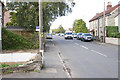
Bath Road in Longwell Green
The A431 but not particularly fast-moving as it passes through the suburbs.
Image: © Bill Boaden
Taken: 28 Sep 2017
0.18 miles
5
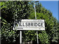
Village Signpost on the A431 Willsbridge Hill
Located at Willsbridge on the north side of the A431 Willsbridge Hill in Oldland parish.
Milestone Society National ID: GL_ST6670V
Image: © Roadside Relics
Taken: 8 Aug 2022
0.20 miles
6
The Chapel Coffee Shop
A former chapel converted to a new commercial use.
Image: © Bill Boaden
Taken: 28 Sep 2017
0.22 miles
7
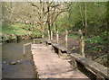
Getting closer to the water
A wooden stage on the Siston Brook, part of Willsbridge Mill's educational attractions.
Image: © Neil Owen
Taken: 27 Mar 2017
0.22 miles
8
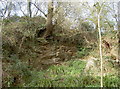
On unsteady ground
The Siston Brook was primarily used for milling, but there was also a number of stone quarrying sites on the valley. Pennant stone was found in abundance and used to create a lot of Bristol's buildings around 1900. Today, the vegetation has tried to re-establish itself, if precariously.
Image: © Neil Owen
Taken: 27 Mar 2017
0.22 miles
9
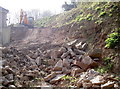
Fresh rock
The banks around the Siston Brook used to have plenty of small quarries that made much of the local Pennant stone; indeed, much of Bristol's early 1900s buildings are made of it. These days this is the only fresh extraction.
Image: © Neil Owen
Taken: 27 Mar 2017
0.23 miles
10
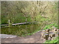
The Teaching Pool
Willsbridge Mill's chief aim these days is to educate and inform; this pond is specifically geared towards some outdoor classwork.
Image: © Neil Owen
Taken: 27 Mar 2017
0.23 miles