IMAGES TAKEN NEAR TO
Westcourt Drive, BRISTOL, BS30 9SB
Introduction
This page details the photographs taken nearby to Westcourt Drive, BS30 9SB by members of the Geograph project.
The Geograph project started in 2005 with the aim of publishing, organising and preserving representative images for every square kilometre of Great Britain, Ireland and the Isle of Man.

There are currently over 7.5m images from over14,400 individuals and you can help contribute to the project by visiting https://www.geograph.org.uk
Image Map (Loading...)


Getting Data...Please wait
Leaflet Map data © OpenStreetMap
Images are licensed for reuse under creativecommons.org/licenses/by-sa/2.0
Notes
- Clicking on the map will re-center to the selected point.
- The higher the marker number, the further away the image location is from the centre of the postcode.
Image Listing (36 Images Found)
Images are licensed for reuse under creativecommons.org/licenses/by-sa/2.0
Image
Details
Distance
1
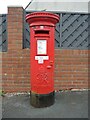
Old box in Oldland
The estates around here are largely post-war developments; a Georgian pillarbox stands on the corner of Westcourt Drive and Glenwood Drive - clearly a reuse from another spot. It is a product of the Carron Company of Stirlingsihre.
Image: © Neil Owen
Taken: 19 Jun 2021
0.03 miles
2
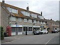
Shops on Westcourt Drive
Three-storey townhouses built along with the rest of the housing here are converted into shops. See Image] for a closer look at the telephone box to see if there is a phone in it.
Image: © Neil Owen
Taken: 19 Jun 2021
0.06 miles
3
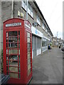
Phone box on Westcourt Drive
As with many, this box has been converted from the spoken word to the written word.
Image: © Neil Owen
Taken: 19 Jun 2021
0.06 miles
4
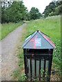
The Covid effect
Litter bins are not being emptied as frequently during the pandemic. Fortunately, this one seems to have capactiy.
Image: © Neil Owen
Taken: 19 Jun 2021
0.10 miles
5
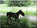
Iron horse by the Siston Brook
There are a few of these steel silhouettes around the area. Perhaps a nod to the old horse-drawn tracks that took the coal from the local pits to the barges.
Image: © Neil Owen
Taken: 19 Jun 2021
0.10 miles
6
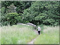
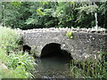
Down to the bridge
A small stone bridge spans the Siston Brook, a structure that has been here for well over a century despite the encroachment of modern housing.
Image: © Neil Owen
Taken: 19 Jun 2021
0.11 miles
7
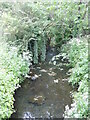
Siston Brook near California Road
The road takes its name form the disused California Colliery that operated nearby in the nineteenth century.
Image: © Neil Owen
Taken: 19 Jun 2021
0.11 miles
8
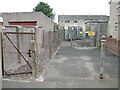
Substation on Westcourt Drive
A bollard prevents use of a handy parking space, while a gate allows access to the rear of properties. See Image] for a closer look at the installation.
Image: © Neil Owen
Taken: 19 Jun 2021
0.12 miles
9
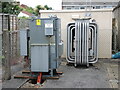
The cables go into the ground
An electricity substation, with the orange cables disappearing into a large hole underneath the hardware.
Image: © Neil Owen
Taken: 19 Jun 2021
0.12 miles
10
California Road bridge
The Siston Brook runs through what used to be the old California colliery.
Image: © Neil Owen
Taken: 19 Jun 2021
0.15 miles