IMAGES TAKEN NEAR TO
Balmoral Road, BRISTOL, BS30 9AL
Introduction
This page details the photographs taken nearby to Balmoral Road, BS30 9AL by members of the Geograph project.
The Geograph project started in 2005 with the aim of publishing, organising and preserving representative images for every square kilometre of Great Britain, Ireland and the Isle of Man.

There are currently over 7.5m images from over14,400 individuals and you can help contribute to the project by visiting https://www.geograph.org.uk
Image Map (Loading...)


Getting Data...Please wait
Leaflet Map data © OpenStreetMap
Images are licensed for reuse under creativecommons.org/licenses/by-sa/2.0
Notes
- Clicking on the map will re-center to the selected point.
- The higher the marker number, the further away the image location is from the centre of the postcode.
Image Listing (14 Images Found)
Images are licensed for reuse under creativecommons.org/licenses/by-sa/2.0
Image
Details
Distance
1
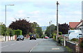
2010 : Court Farm Road, Longwell Green
Looking east toward Willsbridge.
A development mostly of the 1960's and 70's.
That red car is there again, seems to be following me around.
Image: © Maurice Pullin
Taken: 28 Sep 2010
0.07 miles
2
2010 : Windsor Road, Longwell Green
A turning off Court Farm Road.
Image: © Maurice Pullin
Taken: 28 Sep 2010
0.07 miles
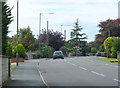
3
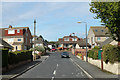
Bath Road in Longwell Green
The A431 but not particularly fast-moving as it passes through the suburbs.
Image: © Bill Boaden
Taken: 28 Sep 2017
0.09 miles
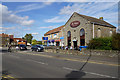
4
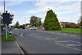
Bath Road at its junction with Long Beach Road
The side road gives access to fairly modern housing estates.
Image: © Bill Boaden
Taken: 28 Sep 2017
0.11 miles
5
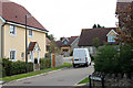
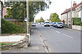
2010 : Stratton Place, Longwell Green
The white van had just turned left off Court Farm Road and was travelling at a modest speed!
Image: © Maurice Pullin
Taken: 28 Sep 2010
0.11 miles
6
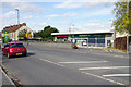
My Local
A supermarket which has not continued trading, and the building is up for rental.
Image: © Bill Boaden
Taken: 28 Sep 2017
0.14 miles
7
2010 : Court Farm Road, Longwell Green, Bristol
Looking west.
Note the pretty lights reminding the motorist he is in a 30mph area. Thought it would be politic to blank his number plate. Don't worry sir/madam, your secret is safe with me.
Image: © Maurice Pullin
Taken: 28 Sep 2010
0.16 miles
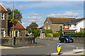
8
The Chapel Coffee Shop
A former chapel converted to a new commercial use.
Image: © Bill Boaden
Taken: 28 Sep 2017
0.19 miles
9
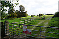
Footpath over grazing land
Leaving Bath Road in the direction of the River Avon and Keynsham.
Image: © Bill Boaden
Taken: 28 Sep 2017
0.19 miles
10
Former chapel on Shellards Road
I think this was once a Wesleyan chapel, but now it is residential.
Image: © Bill Boaden
Taken: 28 Sep 2017
0.22 miles