IMAGES TAKEN NEAR TO
Parkwall Road, BRISTOL, BS30 8HL
Introduction
This page details the photographs taken nearby to Parkwall Road, BS30 8HL by members of the Geograph project.
The Geograph project started in 2005 with the aim of publishing, organising and preserving representative images for every square kilometre of Great Britain, Ireland and the Isle of Man.

There are currently over 7.5m images from over14,400 individuals and you can help contribute to the project by visiting https://www.geograph.org.uk
Image Map
Images are licensed for reuse under creativecommons.org/licenses/by-sa/2.0
Notes
- Clicking on the map will re-center to the selected point.
- The higher the marker number, the further away the image location is from the centre of the postcode.
Image Listing (5 Images Found)
Images are licensed for reuse under creativecommons.org/licenses/by-sa/2.0
Image
Details
Distance
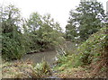
1
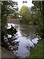
Barr's Court moat
Part of the moat, looking from the large footbridge. See Image] for more views.
Image: © Neil Owen
Taken: 17 Oct 2011
0.20 miles
2
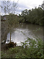
Barr's Court moat
Once a larger feature, part of the eastern side of the moat was filled in during the seventeenth century when a farmhouse was built on the site of the former mansion. See Image] for more views and http://moat1.homestead.com/homepage.html for a comprehensive history.
Image: © Neil Owen
Taken: 17 Oct 2011
0.21 miles
3
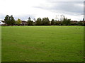
Barr's Court, Bristol
The empty grass area once was home to Sir John and Lady Jane Barre, whose house occupied these grounds in the mid fifteenth century. Records dating back earlier to perhaps the thirteenth century mention a moat here, but the house was enlarged by the Newton family in the sixteenth. However, the buildings were demolished around 1750, leaving an open space. See Image] for more views.
Image: © Neil Owen
Taken: 17 Oct 2011
0.22 miles
4
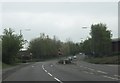
Marsham Way
Marsham Way approaching the junction with Woodward Drive from the north.
Image: © Ruth Riddle
Taken: 4 May 2012
0.22 miles
5
Barr's Court moat
View looking southeast from the small footbridge. See Image] for more views
Image: © Neil Owen
Taken: 17 Oct 2011
0.22 miles