IMAGES TAKEN NEAR TO
Parkwall Road, BRISTOL, BS30 8HH
Introduction
This page details the photographs taken nearby to Parkwall Road, BS30 8HH by members of the Geograph project.
The Geograph project started in 2005 with the aim of publishing, organising and preserving representative images for every square kilometre of Great Britain, Ireland and the Isle of Man.

There are currently over 7.5m images from over14,400 individuals and you can help contribute to the project by visiting https://www.geograph.org.uk
Image Map
Images are licensed for reuse under creativecommons.org/licenses/by-sa/2.0
Notes
- Clicking on the map will re-center to the selected point.
- The higher the marker number, the further away the image location is from the centre of the postcode.
Image Listing (14 Images Found)
Images are licensed for reuse under creativecommons.org/licenses/by-sa/2.0
Image
Details
Distance
1
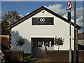
One Church Bristol
In the area of Cadbury Heath
Image: © Chris Allen
Taken: 19 Oct 2019
0.13 miles
2
Parkwall Primary School
The school appears to have houses based on Harry Potter, no less!
Image: © Neil Owen
Taken: 19 Jun 2021
0.15 miles
3
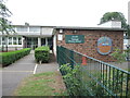
Cadbury Heath library
A library where there is more of an emphasis on engaging the local children with activities and art projects.
Image: © Neil Owen
Taken: 19 Jun 2021
0.17 miles
4
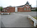
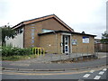
Cadbury Heath hall
The local community hall.
Image: © Neil Owen
Taken: 19 Jun 2021
0.19 miles
5
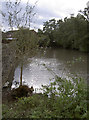
Barr's Court moat
Once a larger feature, part of the eastern side of the moat was filled in during the seventeenth century when a farmhouse was built on the site of the former mansion. See Image] for more views and http://moat1.homestead.com/homepage.html for a comprehensive history.
Image: © Neil Owen
Taken: 17 Oct 2011
0.20 miles
6
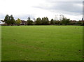
Barr's Court, Bristol
The empty grass area once was home to Sir John and Lady Jane Barre, whose house occupied these grounds in the mid fifteenth century. Records dating back earlier to perhaps the thirteenth century mention a moat here, but the house was enlarged by the Newton family in the sixteenth. However, the buildings were demolished around 1750, leaving an open space. See Image] for more views.
Image: © Neil Owen
Taken: 17 Oct 2011
0.21 miles
7
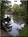
Barr's Court moat
Part of the moat, looking from the large footbridge. See Image] for more views.
Image: © Neil Owen
Taken: 17 Oct 2011
0.21 miles
8
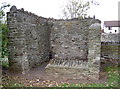
Wall remains of farmhouse, Barr's Court
Some stonework remains of a farmhouse, built in the seventeenth century, utilising some of the masonry of the old mansion located here. Once the home of Sir John and Lady Jane Barre in the 1400s. See Image] for more views.
Image: © Neil Owen
Taken: 17 Oct 2011
0.22 miles
9
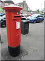
Pillar box on School Road
In the heart of a post-war housing development is a much newer pillar box, made by Romec. The Royal Mail facilities and engineering division was reorganised in 2000: Romec is 51% owned by them and is responsible for the upkeep of the letter box properties. Note the laser-cut and welded sign at the bottom.
Image: © Neil Owen
Taken: 19 Jun 2021
0.22 miles
10
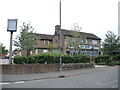
The Lamb on Newton Road
As the estate was developed post-war, there were provisions for a pub along with the other municipal fixtures.
Image: © Neil Owen
Taken: 19 Jun 2021
0.23 miles