IMAGES TAKEN NEAR TO
Woburn Close, BRISTOL, BS30 7HB
Introduction
This page details the photographs taken nearby to Woburn Close, BS30 7HB by members of the Geograph project.
The Geograph project started in 2005 with the aim of publishing, organising and preserving representative images for every square kilometre of Great Britain, Ireland and the Isle of Man.

There are currently over 7.5m images from over14,400 individuals and you can help contribute to the project by visiting https://www.geograph.org.uk
Image Map (Loading...)


Getting Data...Please wait
Leaflet Map data © OpenStreetMap
Images are licensed for reuse under creativecommons.org/licenses/by-sa/2.0
Notes
- Clicking on the map will re-center to the selected point.
- The higher the marker number, the further away the image location is from the centre of the postcode.
Image Listing (10 Images Found)
Images are licensed for reuse under creativecommons.org/licenses/by-sa/2.0
Image
Details
Distance
1
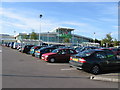
ASDA, Longwell Green
Known as Azdal's in 'Brizzle'.
Image: © William Avery
Taken: 23 Sep 2006
0.18 miles
2
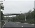
Footbridge crossing Bristol's ringroad
This footbridge allows residents of the housing estate to the south-east of the ringroad to access the open land on the other side, to the south of Cock Road.
Image: © Ruth Riddle
Taken: 4 May 2012
0.18 miles
3
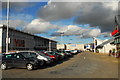
'Aspects', Longwell Green
A new leisure complex with cinema, bowling and numerous restaurants. Just next to the council owned pool and gym centre, so you can work it all off again afterwards!
Image: © Gordon James
Taken: 21 Feb 2010
0.20 miles
4
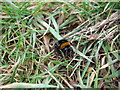
A bee bearing the brunt
It's late February and the big bees have started to emerge. Sadly this bumbler was rather torpid: looking more closely at it there are some pinkish lumps near its head - the presence of bee mites is becoming ever more common, even at this cold time of year.
Image: © Neil Owen
Taken: 23 Feb 2021
0.20 miles
5
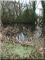
Pond in Cock Road Ridge
The former colliery, quarry and market garden associated with Cock Road are now faint relics. This pond is a new feature of recent age; in the past there was a small building on this spot, possibly related to the limekilns.
Image: © Neil Owen
Taken: 23 Feb 2021
0.21 miles
6
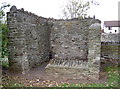
Wall remains of farmhouse, Barr's Court
Some stonework remains of a farmhouse, built in the seventeenth century, utilising some of the masonry of the old mansion located here. Once the home of Sir John and Lady Jane Barre in the 1400s. See Image] for more views.
Image: © Neil Owen
Taken: 17 Oct 2011
0.21 miles
7
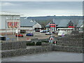
A view of Vue
Aspects Leisure Park has had to shut its doors during the pandemic. One or two cars have plenty of room in the car park. Perhaps they were going to the mobile Test and Trace unit there.
Image: © Neil Owen
Taken: 23 Feb 2021
0.22 miles
8
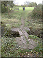
Footbridge over Barr's Court moat
The moat is the prominent remains of what was once a large home in the forest of Kingswood. An impressive mansion was built here in fifteenth century, later added to and altered before being demolished in the 1730s. A farmhouse re-used some of the stone but was itself abandoned in the 1920s, leaving just the ornamental moat. See Image] for more views.
Image: © Neil Owen
Taken: 17 Oct 2011
0.23 miles
9
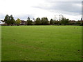
Barr's Court, Bristol
The empty grass area once was home to Sir John and Lady Jane Barre, whose house occupied these grounds in the mid fifteenth century. Records dating back earlier to perhaps the thirteenth century mention a moat here, but the house was enlarged by the Newton family in the sixteenth. However, the buildings were demolished around 1750, leaving an open space. See Image] for more views.
Image: © Neil Owen
Taken: 17 Oct 2011
0.24 miles
10
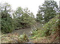
Barr's Court moat
View looking southeast from the small footbridge. See Image] for more views
Image: © Neil Owen
Taken: 17 Oct 2011
0.25 miles